- New legislative panels will investigate ‘facts and circumstances’ of deadly Central Texas floods
- Heavy rain floods downtown Whiteville forcing local businesses to deal with damage again
- New legislative panels will investigate “facts and circumstances” of deadly Central Texas floods
- Springfield Middle School fully reopens next week, a year after devastating EF3 tornado
- Dozens rescued as remnants of typhoon hits Alaska while nor’easter brings flooding to East Coast
Hurricane Dorian 8 a.m.: Now 'catastrophic' Cat 5; greater risk to Ga., Carolinas
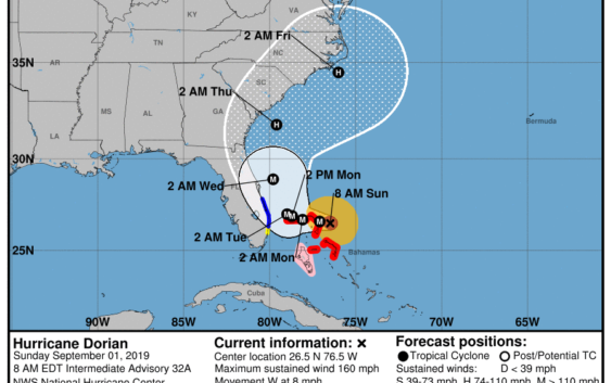
A tortuously slow-moving hurricane Dorian continues to crawl toward the northwestern Bahamas, threatening the tiny islands with devastating 150-mph winds and drowning storm surge.
The storm, which has maintained Category 4 strength for more than 24 hours, is about 255 miles east of West Palm Beach, and about 70 miles east of Great Abaco Island.
With hurricane-force winds extending out 30 miles and tropical-storm-force winds extending 105, the first burst of Dorian’s assault is already upon Marsh Harbour and Coopers Town in Great Abaco.
A tropical storm warning has now been issued for areas of South Florida from Sebastian Inlet to Deerfield Beach.
A tropical storm warning means winds of above 39 mph are expected in an area within 36 hours.
A tropical storm watch has been issued for north of Golden Beach to Deerfield Beach.
Additional tropical storm watches and warnings may be added for the east coast of Florida today.
While the official forecast track changed little overnight, hurricane center forecasters said some recent model runs have shifted Dorian’s path west, putting Florida at a higher risk.
“Although the exact NHC track forecast lies east of the Florida peninsula, a track closer to the coast or even a landfall remain a possibility,” said NHC senior hurricane specialist Dan Brown in his Saturday 11 p.m. forecast.