- U.S.-based aid groups rush to get supplies into storm-battered Jamaica after Hurricane Melissa
- Travelers stuck in Jamaica due to Hurricane Mellissa forced to pay for unwanted extended stay
- Raleigh police officer awaits word from family in Jamaica after Hurricane Melissa devastation
- North Carolina’s leaders give insight on the effects of Hurricane Melissa
- ‘We want some answers;’ Whiteville residents demand city response to prevent flooding
Hurricane Dorian: Southeastern NC, including Fayetteville, under tropical storm watch
Things to know now:
- Dorian has weakened to a Category 2 hurricane and is expected to arrive in North Carolina sometime Thursday.
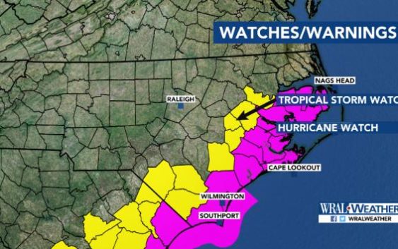
- A hurricane watch has been issued from South Santee River, South Carolina, to Duck, North Carolina.
- A storm surge watch was extended northward to Cape Lookout.
- A tropical storm watch is in effect for Cumberland, Edgecombe, Harnett, Hoke, Johnston, Sampson, Wayne and Wilson counties.
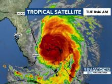
Hurricane Dorian is expected to brush against the North Carolina coast Thursday and Friday, the National Hurricane Center’s Tuesday morning forecast shows.
An updated forecast released at 11 a.m. shows the Category 2 storm crawling northwest away from the Grand Bahama island at 2 mph. At least five people died in the Bahamas.
The storm, with winds at 110 mph, was approaching the Florida coast on Tuesday. It’s expected to move up the East Coast and reach Wilmington as early as Thursday.
“This is going to be a Thursday, Thursday night and Friday event for North Carolina,” WRAL meteorologist Elizabeth Gardner said.

A hurricane watch was issued from South Santee River, South Carolina, to Duck, North Carolina, including the Pamlico and Albemarle sounds, at 11 a.m. A watch is often issued 48 hours before tropical-storm-force winds are first expected.
A storm surge watch was extended to Cape Lookout, which means water moving inland from the coastline could be life-threatening during the next 48 hours.
A tropical storm watch issued for many southeast counties, including Cumberland and Johnston, means winds could gust up to 73 mph when Dorian gets closer to the coast on Thursday. More than four inches of rain could fall there.
Dorian is about 200 miles wide, Gardner said.
The National Hurricane Center’s cone that predicts where the storm could move shows possible landfall on South Carolina or North Carolina. If Dorian makes landfall on North Carolina, it would be east of Interstate 95, Gardner said.
“You have to remember, this storm is enormous,” she said. “We’re going to see rain well inland, most likely at least to Greensboro and Charlotte. We’re going to see winds gusting up to 60 mph with this storm on Thursday into Friday across parts of our viewing area.”
The biggest threat to the North Carolina coast will be Thursday and Friday, Gardner said.
Hurricanes’ winds are usually strongest on the eastern sides of their centers.
“We may end up being spared the strongest winds, but we’re still talking about a Category 2 storm that’s hugging the coast,” Gardner said.
North Carolina will see its first bands of rain from the storm Wednesday night in southeastern parts of the state.
Rain will move into the Triangle on Thursday morning and into Virginia on Thursday afternoon.
Winds are expected to gust up to 60 mph as the storm hits North Carolina.
Dorian is expected to weaken to a Category 1 hurricane by Friday night.
North Carolina’s Emergency Operations Center has been activated and is operating around the clock until the storm passes.
New Hanover County government buildings are closed until further notice as the county prepares for the oncoming storm.
The county’s Emergency Operations Center activated at 7 a.m., and county employees, safety officials and community partners will plan how to keep the public safe.
The University of North Carolina at Wilmington plans to evacuate students Tuesday. Students will go to UNC-Greensboro and UNC-Charlotte.
In the Triangle, workers were preparing a shelter in Durham for evacuees in the former Sears at Northgate Mall. That shelter will allow pets.
Another shelter will have 100 beds for evacuees with special medical needs.
Charlotte Motor Speedway will open its campgrounds for evacuees from the coast, and the SPCA of Wake County says it will take dogs from evacuated shelters.
The state’s swift water and rescue teams and 300 members of the N.C. National Guard have been activated.
President Donald Trump is expected to approve a federal disaster declaration, which would quicken the time it takes North Carolina to get aid after Dorian passes.
Gov. Roy Cooper urged residents to pay attention to evacuation mandates.
The following areas are under evacuation orders:
- Hyde County has ordered a mandatory evacuation of all visitors from Ocracoke Island that went into effect Tuesday at 5 a.m. A mandatory evacuation of Ocracoke residents will go into effect on Wednesday at 5 a.m. Ferries will waive their fees to get visitors off the island.
- A mandatory evacuation has been issued for all Dare County visitors Tuesday at noon. A mandatory evacuation order for all Dare County residents begins Wednesday at 6 a.m.
- Carteret County is under a voluntary evacuation beginning at 8 a.m. Tuesday.