- 3 people dead after North Dakota tornado; 34,000 Minnesotans without power after storms
- I-40 closed again near NC-TN line after rockslide, flooding; TDOT says repairs could take 2 weeks
- Mexico assesses damage from Hurricane Erick as rising rivers leave at least 1 dead
- Houston care home owner creates emergency kits to help seniors during hurricane evacuations
- Flooding and rock slides close heavily damaged I-40 section in Smoky Mountains
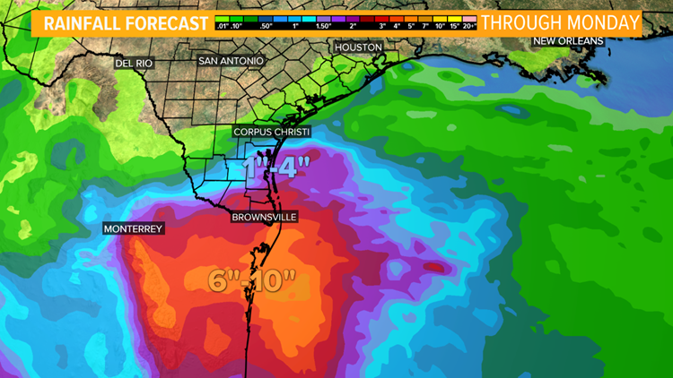
Tropical Storm Fernand forms in gulf, moves towards Mexico
SAN ANTONIO — UPDATE: The tropical depression has formed into Tropical Storm Fernand as of Tuesday afternoon, according to the National Weather Service.
Tropical Depression Seven has formed over the Gulf of Mexico and will move west toward Mexico over the next 36 hours.
A Tropical Storm Warning is in place from La Pesca to Barra El Mezquital. The primary threat from this system will be heavy rainfall that could produce flooding and mudslides, especially in the mountainous areas of Mexico.
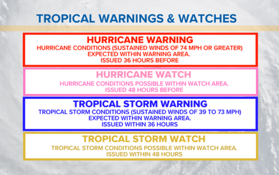
Here’s what each tropical alert means:

KENS 5
Tropical Depression Seven will likely organize into Tropical Storm Fernand Wednesday and the outer bands may bring rain over our southern counties today through Thursday.
KENS 5
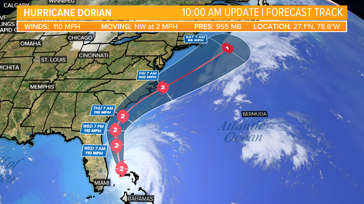
Hurricane Dorian is now a category 2 hurricane now moving to the northwest at 2 mph. The latest forecast track has shifted Dorian east of Florida, however, high wind gusts and heavy rain will still impact portions of Florida’s east coast.
KENS 5
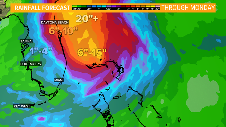
Rainfall forecast today through Monday shows an additional 6″ to 10″ of rain is possible along the coast.
Hurricane Watches and Warnings have been extended along the east coast into the North and South Carolina.
For those within the latest forecast track should prepare for Hurricane Dorian’s impacts like strong wind gusts, storm surge, flash flooding, and heavy rain.
KENS 5
RELATED: Hurricane Dorian growing in size, still a threat to U.S. Mainland
RELATED: 1,400 more flights canceled Tuesday as Hurricane Dorian moves toward U.S.