- Town of Wrightsville Beach preparing for coastal flooding this weekend
- Man charged with sparking the most destructive wildfire in Los Angeles history
- Carolina Hurricanes start 2025-26 season hosting New Jersey Devils
- Speedy Sparks, bassist for Texas Tornados, other San Antonio music icons, has died
- Authorities make an arrest related to deadly January wildfire that leveled LA neighborhood
When, where and how will Hurricane Dorian impact NC? WRAL meteorologists share latest storm updates
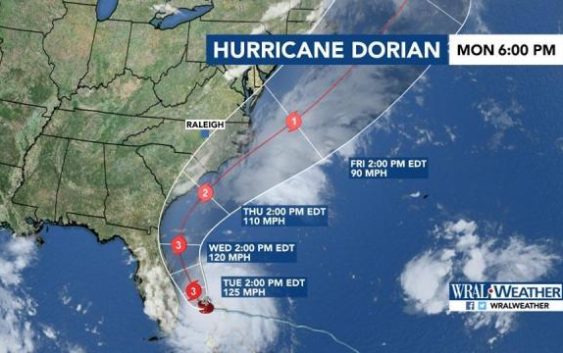
Raleigh, N.C. — Hurricane Dorian is already creating strong rip currents off North Carolina’s coast but the most severe impacts should come late Thursday.
A gradually northeast turn is expected to happen Wednesday and Wednesday night as Dorian runs parallel to Georgia and South Carolina. North Carolina could feel wind gusts from 70 mph at the southern coast to as high as 100 to 105 mph at Cape Lookout and Cape Hatteras on Thursday night.
“The winds pick up Thursday morning and are at their worst Thursday evening and Thursday night,” said WRAL meteorologist Mike Maze. “Of course any deviation of the track will change wind speeds and wind gusts seen there and locally. The strongest winds locally will be along and east of I-95.”

An 8 p.m. updated forecast track from the National Hurricane Center shows the storm approaching North Carolina’s southeast tip as a Category 2 hurricane later this week. This is an improvement from the 8 a.m. update, which showed Dorian hitting North Carolina as a Category 3 storm.
WRAL meteorologist Peta Sheerwood said rainfall totals “look impressive,” with some coastal areas expected to get as much as 10 inches. Raleigh could get up to 1.75 inches of rain, while Wilmington and Beaufort could get almost 8 inches.
Officials were North Carolina and South Carolina asked beach-goers to stay out of the ocean Monday, as Dorian was kicking up rip currents there.

On Friday, the storm is expected to turn and move out to sea.
Dorian, still life-threatening but now a Category 4 hurricane, is moving closer to the United States after wreaking havoc in the Bahamas on Monday.

Cape Lookout in the Outer Banks was already making plans for the hurricane. Visitor centers, public parks and the Cape Lookout lighthouse closed to the public Sunday and will remain closed until after the storm, according to a post from the National Park Service. All islands will be evacuated by noon on Tuesday.
Charlotte Motor Speedway announced that it would open its campgrounds for evacuees from the coast, and the SPCA of Wake County announced it would be taking in dogs from evacuated shelters on Monday afternoon.