- 911 calls from Texas floods reveal chaotic and desperate pleas for rescues
- Carolina Beach is warning of potential King Tide flooding
- NCDEQ launches Hurricane Helene recovery grants program
- Why no hurricanes made landfall in the US in 2025
- Florence to begin interviewing police chief finalists in January
11 a.m. update: Hurricane warning extends north to Virginia border
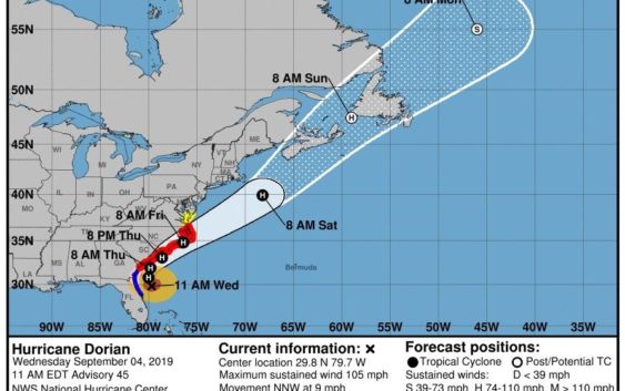
Dorian continues to pick up speed and remains a Category 2 hurricane, projected to reach the Wilmington region late Thursday night
The entire North Carolina coast is now officially under hurricane and storm surge warnings.
As of 11 a.m. Wednesday, Dorian was 205 miles south of Charleston and was moving northwest at 9 mph. the storm’s maximum sustained winds were 105 mph, keeping it a Category 2 hurricane.
Join Our Facebook Group: Join other readers in helping the community know about supplies, closures, damage as Hurricane Dorian approaches
The storm’s track hasn’t changed much over the past 48 hours, but the center of Dorian’s forecast has drifted slightly westward by the time it reaches the North Carolina coast. Landfall in Wilmington is still within the cone of uncertainty, and Dorian should reach local beaches late Thursday night and into Friday morning.
The hurricane and storm surge warnings for New Hanover, Brunswick and Pender counties went into effect Tuesday. A hurricane warning means hurricane-strength winds, sustained winds of at least 74 mph, will reach parts of the region within 36 hours. A Storm Surge Warning means there is a danger of life-threatening inundation, from rising water moving inland from the coastline, during the next 36 hours in the indicated locations.
There is a greater than 70 percent probability of tropical-storm winds in parts of all three counties.
At 6 p.m. Tuesday, the National Weather Service’s Wilmington office increased their confidence to moderate to high that the region will see hurricane force winds Thursday and into Friday morning.
Dorian is growing in size. A turn toward the north is forecast by Wednesday evening, followed by a turn to the north-northeast Thursday morning. The flash flood threat will spread up the southeast coast Thursday, with a high risk in South Carolina and North Carolina coastal areas.
Contact the newsroom at 910-343-2384 or Breakingnews@StarNewsOnline.com.
Send your Dorian photos throughout the week to the StarNews. Use this Google Form!
Got A Dorian Question? Ask the StarNews staff about the hurricane, prep and arrival, and we’ll find the best answer we can.