- Small plane bound for Jamaica with hurricane relief supplies crashes in Florida neighborhood
- Ask the Meteorologist: Did a tornado hit Johnston County Saturday night?
- Demolition begins on flood-damaged homes in Stoney Creek as neighbors await relief
- NC Office of State Fire Marshal aiding in Hurricane Melissa relief efforts
- U.S.-based aid groups rush to get supplies into storm-battered Jamaica after Hurricane Melissa
Hurricane Dorian: Storm to move up NC coast as Category 1 storm
Things to know:
- Hurricane Dorian weakened early Wednesday, with maximum wind speeds reaching 105 mph.
- The storm is expected to move up the North Carolina coast Thursday through Friday as a Category 1 hurricane.
- A hurricane warning is in effect from north of the Savannah River in Georgia to Surf City, North Carolina.
- A tropical storm watch is in effect for Cumberland, Edgecombe, Halifax, Harnett, Hoke, Johnston, Nash, Northampton, Sampson, Wayne and Wilson counties.
Hurricane Dorian is expected to move up the North Carolina coast as a Category 1 storm, the National Hurricane Center said Wednesday morning.
The storm, which was a Category 2 hurricane on Wednesday, weakened slightly with maximum wind speeds reaching 105 mph. It was moving northwest at 8 mph and is expected to get “dangerously close” to Florida’s east cost and the Georgia coast on Wednesday.
Dorian’s center is forecast to move near or over the South Carolina and North Carolina coasts Thursday through Friday morning.
A hurricane warning was issued from north of the Savannah River in Georgia to Surf City, North Carolina. A hurricane watch was issued South Santee River, South Carolina, to the North Carolina/Virginia border, including the Pamlico and Albemarle sounds.
Cumberland, Edgecombe, Halifax, Harnett, Hoke, Johnston, Nash, Northampton, Sampson, Wayne and Wilson counties are under a tropical storm watch, which means winds from 39 mph to 73 mph are possible in the next 48 hours.
A flash flood watch will be in effect for Cumberland, Edgecombe, Harnett, Hoke, Johnston, Nash, Sampson, Scotland, Wayne, and Wilson counties from 4 a.m. Thursday to 12 p.m. Friday.
Cape Lookout to Duck could see 3 to 5 feet of storm surge, and water levels could rise before strong winds come, the National Hurricane Center said.
Coastal communities in North Carolina and South Carolina are expected to see 5 to 10 inches of rain, with some areas seeing 15 inches.
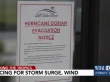
The following areas are under evacuation orders:
- Hyde County ordered all visitors off Ocracoke Island as of 5 a.m. Tuesday and residents off the island by 5 a.m. Wednesday. Ferries will waive their fees to get visitors off the island.
- All visitors had to leave Dare County by noon Tuesday. A mandatory evacuation order for all Dare County residents begins 6 a.m. Wednesday.
- Carteret County began a voluntary evacuation at 8 a.m. Tuesday, and a mandatory evacuation for coastal communities begins at noon Wednesday.
- New Hanover County beaches are under a mandatory evacuation order as of 8 a.m. Wednesday.
“This storm is strong, and it is relentless,” Gov. Roy Cooper said Tuesday afternoon. “We must be ready.”
The U.S. government granted Cooper’s request for a federal disaster declaration for North Carolina, which will speed federal aid to the state. It will bring more FEMA and military personnel as well as resources for preparation and relief efforts.
Dorian devastated parts of the Bahamas, where seven people died as the storm moved through this week.
Residents called the damage “apocalyptic.”