- Demolition begins on flood-damaged homes in Stoney Creek as neighbors await relief
- NC Office of State Fire Marshal aiding in Hurricane Melissa relief efforts
- U.S.-based aid groups rush to get supplies into storm-battered Jamaica after Hurricane Melissa
- Travelers stuck in Jamaica due to Hurricane Mellissa forced to pay for unwanted extended stay
- Raleigh police officer awaits word from family in Jamaica after Hurricane Melissa devastation
Live updates: Some Ocracoke residents trapped amid 'catastrophic' flooding from Hurricane Dorian
Things to know:
- The Outer Banks are experiencing “catastrophic” flooding as Hurricane Dorian’s winds create intense storm surge, the Hyde County Sheriff’s Office said.
- Dorian made landfall over Cape Hatteras, the National Hurricane Center said. It’s still a Category 1 storm.
- More than 190,000 customers are without power in North Carolina, according to the state’s Department of Public Safety.
1:04 p.m. — Members of the North Carolina National Guard were loading an aircraft in Kinston with water and food to take to Ocracoke Island.
Winds were too strong for members to safely conduct rescue operations.
“We’re eager to get out there,” one member said.
12:33 p.m. — Conditions on the North Carolina Outer Banks might not ease up for about six hours, WRAL meteorologist Elizabeth Gardner said.
As Hurricane Dorian’s eye moves northeast away from the state, its western rain bands are drenching areas. Winds are pushing water from the sounds onto land.
12:05 p.m. — Water from the sound was moving onto Highway 64 coming into South Nags Head, with waves rolling onto the road.
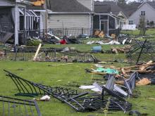
12 p.m. — Residents in Carolina Shores, in Brunswick County, were taking stock of damage from possible tornadoes Thursday.
Wrought-iron fences were torn apart and homes were extensively damaged.
A woman told WRAL’s Kathryn Brown that she was walking her dog when she heard what sounded like a tornado.
She rushed inside with her dog and slammed the door. She watched as her back porch was destroyed.
11:25 a.m. — Water levels have risen on the sound side of Nags Head, WRAL’s Adam Owens reports, as winds continue to gust and push water to land.
“It’s enough to move a person around and make it difficult to stand,” Owens said.
A weak spot in rocks separating the sound from land is allowing choppy waters into a neighborhood.
11:15 a.m. — Part of North Carolina Highway 12 is closed as Ocracoke Island sees severe flooding, the North Carolina Department of Transportation said.
The highway is closed from the village northward.
There are numerous reports of sand and water covering roads on Hatteras Island, the DOT said.
11 a.m. — Hurricane Dorian remains a Category 1 storm with sustained winds reaching 90 mph, the National Hurricane Center said.
Dorian’s eye is 50 miles past Cape Hatteras moving northeast at 17 mph.
10:50 a.m. — Areas in Nags Head were becoming flooded as gusts created waves in the sound.
“You could almost swear it’s the ocean,” WRAL’s Adam Owens said.
Gusts were pushing water from the sound onto land, flooding parts of the town.

“This exact kind of action is exactly what is causing so much trouble in Hyde County and in Ocracoke, the kind of force that is causing serious flooding, floating cars, causing a lot of damage and danger to people south of us,” Owens said.
“We are really not done with this storm,” he said.
10:37 a.m. — Roads in Frisco and Buxton were impassable, a resident said, as high water started flooding areas from intense storm surge.
“When the eye came through, we got skies and the sun was out, and it got calm, of course,” Donny Bowers said. “Within 10 minutes, the water came up probably a couple feet, and we had a really bad band there from the western eye wall. The winds were much more intense on that side than it was on the other side.”
He said he’s seen trees, debris and cable lines on the ground. Rain was falling sideways.
“The conditions are just so horrific out here right now,” he said.

10:30 a.m. — People were using boats and jet skis on Ocracoke Island to help take others to higher ground, resident Scott McNally said.
“We’re just trying to take care of people right now,” McNally said.
Video posted to social media showed an area of higher ground where many people park their cars during storms was flooded.
“If it’s flooded down there, that’s not good,” McNally said.
10:05 a.m. — Gov. Roy Cooper said Outer Banks residents should continue to shelter, stay off the roads and stay alert as Hurricane Dorian starts to move away from North Carolina. He said 15,000 residents in the state are without power but those numbers should start to drop. Cooper said more than 70 roads are impassable from debris and motorists should not drive through roads covered with water.
10 a.m. — Hyde County officials are sending deputies, medics and authorities with NC Wildlife Resources Commission and Marine Patrol to Ocracoke Island to help people experiencing “catastrophic” flooding, the county sheriff’s office said on Facebook.
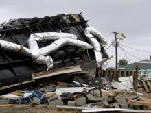
9:52 a.m. — Sky 5 showed homes damaged by tornadoes Thursday in Calabash.
Sidings from houses were on streets, and trees had fallen.
Some low areas had standing water.
Some trees were down in Sunset Beach.
9:25 a.m. — A large part of Atlantic Beach was flooded in Atlantic Beach near Fort Macon Road.
The water is “dangerously close” to houses, WRAL’s Sloane Heffernan said.
A resident said his neighborhood often floods in thunderstorms and said the standing water came from Dorian’s rain.
He and his wife stayed in their home during the storm because they didn’t have enough time to evacuate, he said.
The storm, the man said, was “noisy.”
“A lot of wind, a lot of rain,” he said.
9:10 a.m. — A resident of Ocracoke Island told WRAL News said his house on Ocracoke Island is flooding as storm surge brings high water to land.
“I’ve never seen the water like it has been,” Scott McNally said. He’s lived on the island for 25 years.
He’s 6-foot-2, and the water is up to his neck, he said.
People in flooded areas should get to the highest level of their house or on their roofs if needed and should not go into floodwaters.
9:05 a.m. — Hyde County is seeing “historic” damage from Hurricane Dorian, an emergency management worker told WRAL’s Adam Owens.
“We have been talking about how we’ve been mostly fortunate,” Owens said. “That has completely turned.”
As storm surge continued to rise on the side of the sounds, water entered homes and floated cars, the emergency management worker said.
There were discussions about using aircraft to try to rescue people, Owens said.
“You can hear in their voice their concern,” he said.
8:55 a.m. — Hurricane Dorian made landfall over Cape Hatteras on at 8:35 a.m. Friday as a Category 1 hurricane, the National Hurricane Center said. It’s the only place in the United States where the center of the eye moved over land.
Dorian’s sustained winds reached 90 mph.
The eye had come on shore near Morehead City and Cape Lookout.
Waters were continuing to quickly rise at the back of Ocracoke Island and the North Carolina sounds.

8:20 a.m. — A gauge that the United States Geological Survey keeps at Ocracoke Island shows rapidly rising waters, indicating intense storm surge, WRAL meteorologist Elizabeth Gardner said.
Because the sounds at the North Carolina coast are a “very unusual topographical feature,” Gardner said, they could get hit particularly hard from storm surge on both sides as Dorian moves northeast.
“It would be like this is a sink and you took your hand and you pushed the water, and of course it sloshed up over the edge of the sink,” Gardner said.
8:10 a.m. — A tropical storm warning has been canceled for Wake, Cumberland, Franklin, Harnett, Hoke, Johnston and Sampson counties.
8:05 a.m. — WRAL’s Adam Owens was in Nags Head as winds gusted heavily.
“This is the first time I feel like I’m really starting to feel this storm,” Owens said, explaining that he had felt a gradual increase of wind speeds before they became worse.
“Without it relenting in any way, we’re really starting to feel that wind become a constant hit,” he said.
8 a.m. — Dorian’s eye was nearing Cape Hatteras. The storm will officially make landfall if the center of the eye moves over the cape.
Gusts reached 70 mph at Cape Hatteras.
Sustained winds reached 69 mph at Ocracoke Island as the storm moved through, with gusts at 89 mph.
Dorian’s bands were moving out of central North Carolina as the storm moved northeast.
“Our conditions are improving pretty rapidly this morning,” WRAL meteorologist Elizabeth Gardner said.
7:45 a.m. — The Town of Oak Island tweeted that its curfew has lifted and bridges are open.
7:20 a.m. — Richard Neal, owner of the Frying Pan Shoals Light Tower, told WRAL News he’s staying in Charlotte during Hurricane Dorian. He watched a dark livestream of the tower overnight and said he was relieved to see an American flag still flying at sunrise.
Winds tore at the flag Thursday as Dorian moved in, and Neal said he’ll replace it as soon as he can.
As Hurricane Florence battered North Carolina last year, an American flag flying atop the tower became an iconic image. That flag was later auctioned and sold for nearly $11,000 to a family in Ohio.
The money was donated to the American Red Cross.
7 a.m. — More than 208,000 customers throughout North Carolina are without power, according to the state’s Department of Public Safety. Nearly 37,000 of those are in Carteret County.
6:50 a.m. — While Wake County got 1 to 3 inches of rain in the past 24 hours, 6 to 8 inches of rain fell from Clinton to Indian Springs, WRAL meteorologist Elizabeth Gardner said.
6:45 a.m. — One-stop voting for the 9th Congressional District special election resumes today on its normal schedule in Cumberland County, officials said.
6:20 a.m. — Ocracoke Island was in the eye wall as Hurricane Dorian continued hugging the coast, making a direct hit.
“They’re really getting slammed,” WRAL meteorologist Elizabeth Gardner said.
While the center of the eye hadn’t crossed over land, the hurricane could make landfall at Cape Hatteras.
“Cape Hatteras may stick out just far enough that the Hurricane Center calls it as landfall,” Gardner said. “It’s going to be awfully, awfully close.”
Storm surge was worsening along the coast as heavy winds were gusting.
Farther inland, Goldsboro had seen gusts up to 53 mph, and the Triangle had seen gusts up to 43 mph.
Rain should move out of the Triangle by 10:30 a.m., and Dorian is expected to move off-shore by Friday evening.
Gardner recommended people give crews time to examine and clear damage before getting on the roads this morning.
5:05 a.m. — Carteret County emergency officials are in a holding pattern until winds weaken and it’s safe to examine damage.
“We are feeling some serious hurricane-force gusts,” WRAL’s Sloane Heffernan said.
Officials have received a few reports of downed trees but no reports of flooding, the county manager told Heffernan.
Heffernan and photojournalist Greg Clark had to tie a light stand to their hotel building in Havelock to keep it from blowing away. Even with sand bags, the light had toppled over.
5:02 a.m. — Six Forks Road in Raleigh was cleared of standing water at Shelby Drive as crews were able to fix a clogged storm train, WRAL’s Emmy Victor reports.
5 a.m. — Dorian remains a Category 1 hurricane, with maximum sustained winds at 90 mph, the National Hurricane Center said.
Coastal flooding was reported in Hyde County, and it’s expected to worsen as the storm moves northeast at 14 mph.

The eye was pulling away from Cape Lookout, where it was “so close” to making landfall, WRAL meteorologist Elizabeth Gardner said.
She said the biggest damage in Wilmington is likely from tornadoes that struck.
There have been 14 reports of tornado damage since 5 a.m. Thursday, with three confirmed tornadoes in the WRAL viewing area.
Future tornadoes are most likely north of Dorian’s center, Gardner said.
4:45 a.m. — Northwoods Fire and Rescue in Lumberton posted on Facebook that a tree struck a member’s personal vehicle while he wa driving to the station in Tolarsville. The member was trapped and needed to be extracted from the vehicle. He was transported to a hospital and was being treated for non-life-threatening injuries.
4:20 a.m. — There are 142,100 power outages in North Carolina, according to the state’s Department of Public Safety. Brunswick, New Hanover and Carteret counties have the most outages.
4:05 a.m. — Adam Owens is in Nags Head, where heavy rain accompanied gusty winds.
“Mother Nature wants to put on a good show for us,” Owens said.
The winds, he said, was constant, but at times rain seemed to lift.
“That’s not the case anymore,” he said.
The ocean’s waves, he said, were approaching the dune line.
4 a.m. — Part of Dorian’s eye is over Cape Lookout, bringing gusts up to 90 mph.
Landfall, in which the center of the eye moves over land, looks unlikely, WRAL meteorologist Aimee Wilmoth said.
“I don’t think we’re going to have a landfall at this point,” WRAL meteorologist Aimee Wilmoth said as the storm moves northeast at 14 mph.

3:45 a.m. — Dorian’s eye is very close to the Morehead City, Emerald Isle and Cape Lookout area. Winds are registering around 78 mph. If you’d like to see conditions at the Bogue Inlet Pier in Emerald Isle, click here to watch this live cam.
3:35 a.m. — The Outer Banks is bracing for the worst. WRAL’s Adam Owens is there and reports rain and wind come and go with high gusts. The surf is hitting the beach hard but hasn’t reached the roads yet in areas like Nags Head and Kitty Hawk. It’s likely a different story in the Cape Hatteras and Buxton area, where it typically floods along NC Highway 12.
3:19 a.m. — WRAL’s Sloane Heffernan is in Morehead City and spoke with Christopher Peterson, who lives in New Bern and lost his home during Hurricane Florence nearly a year ago. He said with Dorian approaching, the family felt is was best to take cover at a safer place this time. He was in a hotel where first responders were staying.
“Where we live in New Bern is very susceptible to flooding, so they did a voluntary evacuation,” Peterson said. “We have four dogs, four cats at home so we figured it was best to pack up and come some place safer.”
2:56 a.m. — Since 1944, these major storms have slowed 17%, according to a recent study by NASA and NOAA scientists.
2:45 a.m. — Meteorologist Kat Campbell said she does not believe the center of Dorian will cross over Cape Lookout. The case is still uncertain for Cape Hatteras. However, she said many areas in and around Cape Lookout will still experience the strongest winds from the eye wall because it is currently still well defined. The eye of the storm is currently 18 miles from Cape Lookout.

2:41 a.m. — Adam Owens is also at the Outer Banks and reports from Nags Head that the wind is picking up. It’s pushing up surf but not to storm surge levels. He said there have been few reports of power outages and damage, mainly because the brunt of the storm hasn’t arrived yet. That will change as the storm gets closer.
2:36 a.m. — Joe Fisher was in the Breaking News Tracker on Interstate 40 heading to Sampson County, which was getting hit hard from Dorian. He reports steady rain and wind, which has tossed some debris on the road. He also reports ponding on the roads.
1:53 a.m. — The latest flash flood warnings:.
— Cumberland, Harnett, Johnston, Sampson, Wayne, and Wilson counties until 3:30 a.m.
— Duplin and Lenoir counties until 6:30 a.m.
The latest flash flood watches:
— Bladen and Robeson counties until 8:00 a.m.
— Cumberland, Duplin, Edgecombe, Franklin, Halifax, Harnett, Hoke, Johnston, Lenoir, Nash, Sampson, Scotland, Wake, Wayne, and Wilson counties until 2:00 p.m. Friday
— Hertford and Northampton counties until 8:00 p.m. Friday
1:38 a.m. — There are over 6,500 people now without power in Robeson County, according to Duke Energy. Scott Mason reports there were around 150 people in shelters, too.
1:31 a.m. — Over 92,000 power outages are now reported by Duke Energy, NC Electric Services, Dominion Energy and ElectriCities.
1:25 a.m. — Meteorologist Kat Campbell reports Dorian is down to 90 mph, which makes it a Category 1 storm. It is moving northeast at 15 mph and is now just east of Wilmington. It’s expected to stay a Category 1 storm and is projected to come very close to landfall, moving just east of Cape Lookout and just east of Cape Hatteras.
1:15 a.m. — There are confirmed reports of roads either flooded or washed out at numerous locations in Sampson County. Along Interstate 40, the NC DOT reports there were reports of flooding at exits 355 and 359. In New Hanover County, there are now over 15,000 power outages reported by Duke Energy.
12:48 a.m. — Julian Grace spoke with a Wilson County resident says she is “truly blessed” to have heard and seen a tornado pass without suffering any injury or serious damage to her home.
12:27 a.m. — WRAL’s Kasey Cunningham was at the Carteret County Emergency Management office where the people working there were hunkered down for the night in anticipation of the phone calls they would be getting in the morning. They have a plan in place they used to success during Hurricane Florence and expect to do it again.
12:02 a.m. Friday — WRAL’s Aaron Thomas is in Wayne County and reports more than 100 people were taking advantage of shelters. There was a curfew in place from 9 p.m. until 6 a.m. on Friday. Driving around, Thomas saw some damage, including in the Crestwood neighborhood of Mar-Mac. He spoke with Donnie King, who was busy fixing siding on his home and cleaning up debris in his yard.
“It was frightening as anything I’ve been through,” King said. “I looked outside my shop and trees were going and all I could see was a wind that was just furious.
Thomas also reported about 600 people without power.
For previous Hurricane Dorian updates: Click here