- New legislative panels will investigate ‘facts and circumstances’ of deadly Central Texas floods
- Heavy rain floods downtown Whiteville forcing local businesses to deal with damage again
- New legislative panels will investigate “facts and circumstances” of deadly Central Texas floods
- Springfield Middle School fully reopens next week, a year after devastating EF3 tornado
- Dozens rescued as remnants of typhoon hits Alaska while nor’easter brings flooding to East Coast
Tropical Storm Imelda Forms In Gulf, Can Cause Flooding In Upper Texas Coast
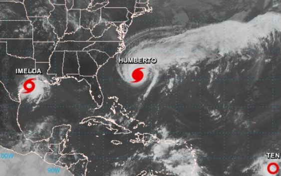
This satellite image from the National Weather Service shows Tropical Storm Imelda making its way into the Texas coast.
The National Hurricane Center upgraded Tuesday Tropical Depression 11 to Tropical Storm Imelda and said it’s likely to produce heavy rainfall flash flooding along portions of the Upper Texas coast, including the Houston and Galveston areas, and Brazoria County.
At 12 p.m., the system was moving toward the north near 7 mph and the National Hurricane Center expected that pattern to continue through early Wednesday. The forecast indicated the center of the depression would move farther inland on Tuesday night and Wednesday.
The system is expected to produce total rainfall accumulation of 5 to 10 inches with isolated maximum of 15 inches across the upper coastal region of Texas into far southwest Louisiana through Thursday. The National Hurricane Center said the rainfall may produce life-threatening flash floods.
The weather forecast already impacted regional school districts on Tuesday around midday. The Galveston Independent School District announced it was canceling classes on Wednesday.
After careful consideration of weather conditions concerning the eminent rain event in the Gulf of Mexico, Galveston ISD is announcing the decision to cancel classes for students Wednesday, September 18, 2019. Full report: https://t.co/NjfH2vfvAu pic.twitter.com/LwthQ7OaBd
— Galveston ISD (@galvestonisd) September 17, 2019
This is a developing story.