- Families of campers, counselors who died in Texas Hill County floods sue Camp Mystic
- Small plane bound for Jamaica with hurricane relief supplies crashes in Florida neighborhood
- Ask the Meteorologist: Did a tornado hit Johnston County Saturday night?
- Demolition begins on flood-damaged homes in Stoney Creek as neighbors await relief
- NC Office of State Fire Marshal aiding in Hurricane Melissa relief efforts
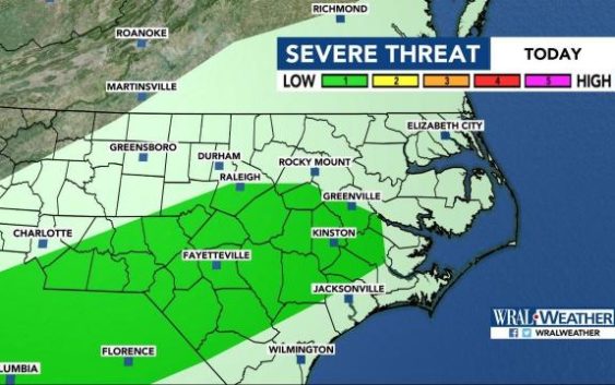
Severe weather possible Sunday, cool down coming in time for NC State Fair
Raleigh, N.C. — A round of much-needed rain will arrive Sunday afternoon then leave before returning in the middle of the work week and bringing us much cooler temperatures.
The lower half of Wake County and other counties south of the Triangle are under a level 1 risk for severe weather Sunday.
The chance for rain and some storms is greatest Sunday afternoon and evening, with some rain also falling overnight. Although a stray shower can’t be ruled out all day, the best chance for rain is after lunchtime.
Highs will top out around 75 degrees in Raleigh on Sunday, and temperatures will get as cool as 60 degrees overnight. Heavy downpours and gusty winds will be likely at times throughout central North Carolina.
The rain should taper off by early Monday morning, leaving behind a partly sunny and dry start to the work week, though afternoon showers will be possible, mainly south of the Triangle, Sheerwood said. Highs on Monday will be in the upper 70s.

The chance for rain returns very late Tuesday, with showers and storms likely overnight and into Wednesday. Both Tuesday and Wednesday will be warm, with highs in the mid 70s. Wednesday can be considered the rainiest day of the week, with a 60 percent chance for precipitation much of the day.

The rain will move out by Thursday, leaving behind much cooler temperatures — possibly the coolest of the season so far. Highs will be in the mid 60s Thursday and Friday, giving Raleigh a taste of fall for the opening of the North Carolina State Fair.