- Demolition begins on flood-damaged homes in Stoney Creek as neighbors await relief
- NC Office of State Fire Marshal aiding in Hurricane Melissa relief efforts
- U.S.-based aid groups rush to get supplies into storm-battered Jamaica after Hurricane Melissa
- Travelers stuck in Jamaica due to Hurricane Mellissa forced to pay for unwanted extended stay
- Raleigh police officer awaits word from family in Jamaica after Hurricane Melissa devastation
Severe weather risk for NC could bring thunderstorms, damaging winds
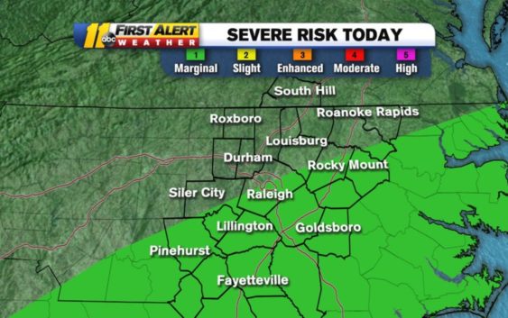
Showers and a few thunderstorms will move across North Carolina on Tuesday, bringing a severe weather risk to the area.
Temperatures are above normal this morning, showing 60s in some spots, with clear skies. But a line of showers moving in from our west will change that.
Counties south and east of the Triangle are under a marginal risk for severe weather. There’s a small chance for an isolated storm that could produce gusty winds. The highest chance for rain will come around noon and it will likely arrive earlier in the western counties.
Over 20 million Americans are under a Marginal (Cat 1 of 5) Risk for severe weather today, including the SE 1/2 of our viewing area. Biggest threat=damaging winds #ncwx pic.twitter.com/SA5ZpdqaOh
— Don Schwenneker (@BigweatherABC11) December 17, 2019
It’ll cool down significantly on Wednesday, with morning temperatures only in the 30s.
Copyright © 2019 WTVD-TV. All Rights Reserved.