- Families of campers, counselors who died in Texas Hill County floods sue Camp Mystic
- Small plane bound for Jamaica with hurricane relief supplies crashes in Florida neighborhood
- Ask the Meteorologist: Did a tornado hit Johnston County Saturday night?
- Demolition begins on flood-damaged homes in Stoney Creek as neighbors await relief
- NC Office of State Fire Marshal aiding in Hurricane Melissa relief efforts
Level 1 severe weather threat, winds upwards of 40 mph overnight Saturday
The weather feels more like April than January this weekend, with warm, moist air and even the potential for thunderstorms and gusty winds.
Unseasonably warm weather makes Saturday a great time to enjoy outdoor activities, even with cloudy skies. But as we head into Saturday evening and overnight, a cold front brings the potential for strong or even severe storms, putting the Triangle under a level 1 threat for severe weather.
A strong system currently moving across middle of the country is creating showers, thunder storms, and isolated tornados as it moves east, and will likely pass over North Carolina Saturday evening and overnight.
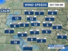
The winds could gust upwards of 30 mph today, and should pick up as the system gets closer, gusting from 35 to 45 mph after 10 p.m.
“It’s a good time to have that WRAL Weather app handy to alert you if the weather gets severe overnight,” said WRAL meteorologist Peta Sheerwood.
The gloomy, cloudy, warm weather could continue through Sunday and Monday, as temperatures remain above 60 degrees, and the potential for rain lingers through Wednesday.
