- Tropical Storm Melissa lumbers through the Caribbean as islands take cover from rain
- Tropical Storm Melissa brings flood risk to Haiti, Dominican Republic and Jamaica
- Army Corps evaluates Wrightsville Beach storm damage; could accelerate re-nourishment plans
- Austin and Travis County issue disaster declaration as wildfire risk rises
- Raleigh rethinks how to grow as flooding, heat and traffic worsen
Central NC under level 1 risk for severe weather Tuesday afternoon
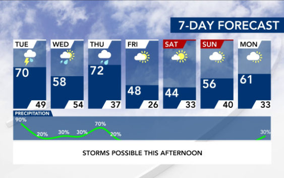
Raleigh, N.C. — Thunderstorms that could be severe in nature will move into the Triangle Tuesday afternoon.
According to WRAL meteorologist Elizabeth Gardner, thunderstorms could move into northwestern counties by 1 p.m. Storms could be in the Triangle by 3 or 4 p.m. and are forecast to move out of central North Carolina around 6 p.m.
The area is under a level 1 risk for severe weather, and there is a small chance for strong winds and an isolated tornado.
“This won’t be like last week’s storms, but we still need to take it seriously,” Gardner said. “We’re not looking at a widespread threat for severe weather or storms.”
Track the rain with the DualDoppler5000
Strong wind shear is expected, but there will be weak forcing and limited instability, so storms won’t be extreme.
According to Gardner, rain will be heaviest north and west of the Triangle.
Get WRAL Weather alerts on your device.
Highs will be in the upper 60s and 70s throughout central North Carolina on Tuesday before dipping into the 50s on Wednesday, which will be sunny.
Thursday will be even warmer, with highs in the 70s, and a storm system in the western United States could bring storms to North Carolina again.
After that, temperatures plunge with highs in the 40s on Friday and Saturday before reaching the 50s on Sunday.