- Tropical Storm Melissa lumbers through the Caribbean as islands take cover from rain
- Tropical Storm Melissa brings flood risk to Haiti, Dominican Republic and Jamaica
- Army Corps evaluates Wrightsville Beach storm damage; could accelerate re-nourishment plans
- Austin and Travis County issue disaster declaration as wildfire risk rises
- Raleigh rethinks how to grow as flooding, heat and traffic worsen
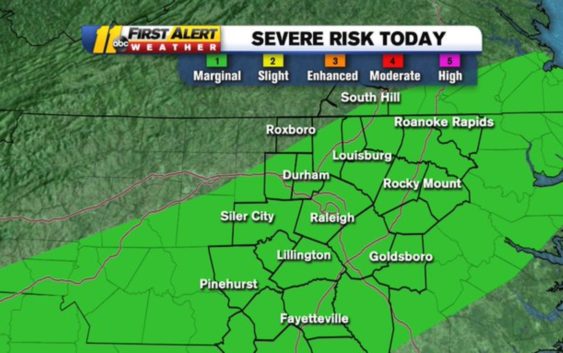
Central NC under severe weather risk, damaging winds possible
More rain is on the way for central North Carolina in the coming days, and with it comes a small chance for severe weather.
As most places are seeing a big warm-up on Tuesday morning, the National Weather Service has every county in the ABC11 viewing area under a Category 1 ‘marginal’ risk for severe weather on Tuesday afternoon.
The @NWSSPC now has every county in our viewing area under a Cat 1 (Marginal) of 5 risk for severe weather this afternoon. Biggest threat= isolated damaging wind gust or brief tornado. Almost 20 million Americans included in this risk. #ncwx pic.twitter.com/9M18QMXykT
— Don Schwenneker (@BigweatherABC11) February 11, 2020
The risk extends through Alabama, Georgia and the carolinas.
In North Carolina, rain should move in during the early morning hours with scattered showers stick around through lunchtime.
We expect a few periods of rain today with the best chance coming this afternoon and early tonight. Between 3 and 7 p.m., we’ll see some thunderstorms with possible gusty winds.
The biggest threat for us is an isolated damaging wind gust and even a brief tornado.
Tuesday’s threat comes days after storms caused power outages, property damage and several schools to close last week.
Copyright © 2020 WTVD-TV. All Rights Reserved.