- 911 calls from Texas floods reveal chaotic and desperate pleas for rescues
- Carolina Beach is warning of potential King Tide flooding
- NCDEQ launches Hurricane Helene recovery grants program
- Why no hurricanes made landfall in the US in 2025
- Florence to begin interviewing police chief finalists in January
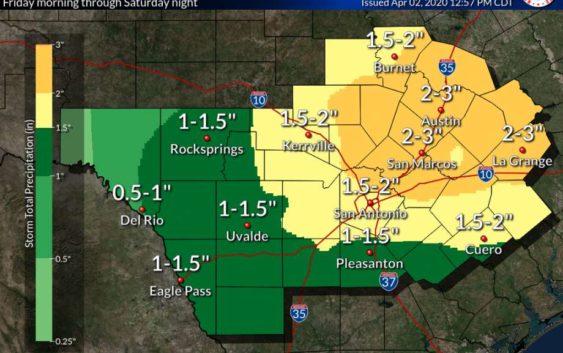
NWS: Severe thunderstorms Friday could bring large hail, damaging winds to San Antonio
-
The San Antonio area could face severe thunderstorms on Friday, according to the National Weather Service.
The San Antonio area could face severe thunderstorms on Friday, according to the National Weather Service.
Photo: National Weather Service
The San Antonio area could face severe thunderstorms on Friday, according to the National Weather Service.
The San Antonio area could face severe thunderstorms on Friday, according to the National Weather Service.
Photo: National Weather Service
The San Antonio area could face severe thunderstorms on Friday, according to the National Weather Service.
A cold front moving through the region Friday afternoon is expected to trigger widespread showers and thunderstorms, the NWS said.
A few of the storms Friday afternoon and evening could be severe, with large hail — up to 2 inches in diameter — and damaging winds. Those storms may also produce heavy rain, with moderate rainfall expected into Saturday morning.
READ ALSO: Mayor plans to extend stay-home order in San Antonio
One to 3 inches of rain is expected in many area, with isolated locations receiving up to 4 inches. Flash flooding is possible, the NWS said.
While a tornado late Friday cannot be completely ruled out, the potential is low.
The NWS forecasts thunderstorm wind gusts up to 70 mph.