- U.S.-based aid groups rush to get supplies into storm-battered Jamaica after Hurricane Melissa
- Travelers stuck in Jamaica due to Hurricane Mellissa forced to pay for unwanted extended stay
- Raleigh police officer awaits word from family in Jamaica after Hurricane Melissa devastation
- North Carolina’s leaders give insight on the effects of Hurricane Melissa
- ‘We want some answers;’ Whiteville residents demand city response to prevent flooding
Damaging winds, hail to affect several central NC counties Wednesday night
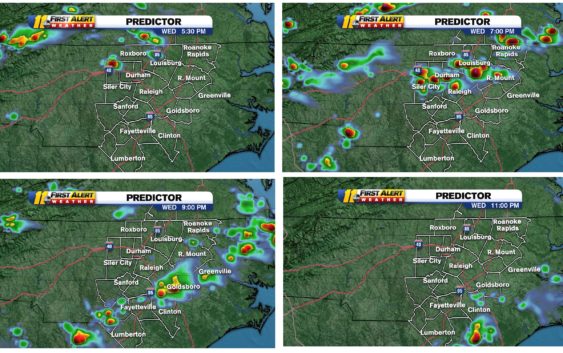
RALEIGH, N.C. (WTVD) — A cluster of thunderstorms are rolling in from southwest Virginia that could bring damaging winds that could reach up to 60 mph and quarter-sized hails are all possible.
Central North Carolina is beginning to see its first wave of severe weather as a Severe Thunderstorm Warning was put in place for Durham, Franklin, Granville, Person, Vance and Wake counties until 6:45 p.m.
Raleigh will likely see these storms anywhere between 8:30 p.m. to 10 p.m.
Over the last two days, our viewing area has been under a Marginal, or Category 1 of 5, risk for severe storms. Today, it’s increased to a Category 2 (Slight) risk,
This model is called the HRRR (High Resolution-Rapid Refresh) and it updates several times a day, based on new data being ingested into the model. But as of 10 a.m. this morning, this is what it looked like with the possible timing between 5 p.m. and 9 p.m. It certainly could change throughout the day.
RELATED | The local weather forecast
You just want to make sure you are weather-aware anytime this afternoon and evening.
Though we are in the slight risk area, there is actually a higher risk to our North and West through the Ohio Valley. As a matter of fact, over 80 million Americans are under a severe threat today.
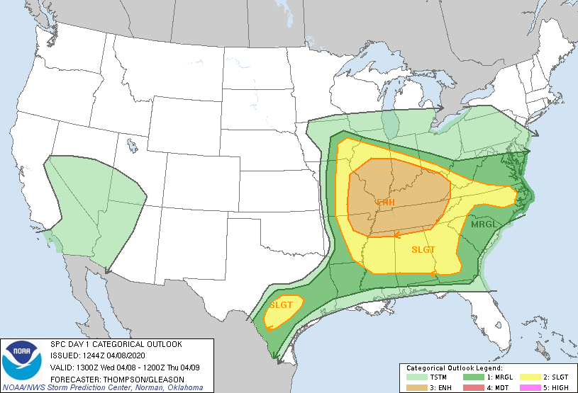
Chief Meteorologist Chris Hohmann and Meteorologist Brittany Bell will be watching all afternoon and will First Alert you to any warnings that are issued. By the way, there is a Category 1 (Marginal) risk for Thursday as well. Stay tuned…
Copyright © 2020 WTVD-TV. All Rights Reserved.