- Raleigh rethinks how to grow as flooding, heat and traffic worsen
- New legislative panels will investigate ‘facts and circumstances’ of deadly Central Texas floods
- Heavy rain floods downtown Whiteville forcing local businesses to deal with damage again
- New legislative panels will investigate “facts and circumstances” of deadly Central Texas floods
- Springfield Middle School fully reopens next week, a year after devastating EF3 tornado
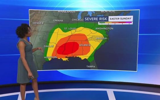
Strong to severe storms expected on Sunday, potential for damaging winds, isolated tornadoes into early Monday
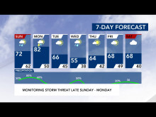
Saturday was another nice day and a good start to the Easter holiday. Sunday is likely to be a different story.
Easter Sunday, the temperatures are forecast to rise back into the 70s, bringing rain and a level 2 risk for severe weather — including damaging winds, hail and even isolated tornadoes.
“This is the time to download that WRAL Weather app and track those storms with us as they move through,” said Peta Sheerwood, WRAL’s meteorologist.
Sunday brings a high of 71, but the scattered rain chances will increase as the day goes, up to 50 percent by the mid-afternoon.

“Severe storms will be arriving on Sunday, maybe as early as the late afternoon and evening,” WRAL meteorologist Zach Maloch said. “Some of those storms will be on the stronger side. Then we’re tracking a line of storms that will push through the area. That’s going to arrive overnight and the next few days, as well.”
The best chance for severe weather will start around 3 a.m. Monday with the bulk of the storms hitting the Triangle by 7 a.m.

These storms carry the potential for damaging winds and hail — even an isolated tornado can’t be ruled out.

Monday’s high could reach into the 80s, but the temperatures will cool through out the week, dropping into the 60s on Tuesday and 50s on Wednesday.