- Tropical Storm Melissa lumbers through the Caribbean as islands take cover from rain
- Tropical Storm Melissa brings flood risk to Haiti, Dominican Republic and Jamaica
- Army Corps evaluates Wrightsville Beach storm damage; could accelerate re-nourishment plans
- Austin and Travis County issue disaster declaration as wildfire risk rises
- Raleigh rethinks how to grow as flooding, heat and traffic worsen
FORECAST: Heavy rain with flooding possible
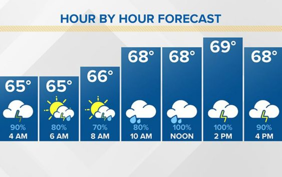
A FLASH FLOOD WATCH is in effect through Thursday morning for the entire area. Rainfall totals could range from three to seven inches—between today and Friday.
Look for periods of rain and some thunderstorms today, with rain heavy at times, with highs in the low 70s. More rain is likely tonight with a few thunderstorms. Lows will be in the mid 50s. Wednesday will be much cooler, with highs in the low to mid 60s. More heavy rain is likely with flooding a possibility,
Tropical Storm Arthur’s winds are 60mph and has moved away from the Outer Banks and is moving out into the Atlantic Ocean. The storm is no longer a threat to the coastal areas of North Carolina.