- Raleigh rethinks how to grow as flooding, heat and traffic worsen
- New legislative panels will investigate ‘facts and circumstances’ of deadly Central Texas floods
- Heavy rain floods downtown Whiteville forcing local businesses to deal with damage again
- New legislative panels will investigate “facts and circumstances” of deadly Central Texas floods
- Springfield Middle School fully reopens next week, a year after devastating EF3 tornado
Flash Flood Watch in effect for central North Carolina
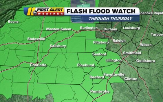
RALEIGH (WTVD) — We’re First Alerting you as parts of central North Carolina are under a Flash Flood Watch on Wednesday.
The watch lasts through Thursday night and effects Alamance, Chatham, Lee, Cumberland, Hoke, Moore, Harnett, Robeson and Scotland counties. Most of North Carolina saw significant rain on Tuesday and it’s going to be another soaker on Wednesday and Thursday.
Some of the heaviest rain will fall late Wednesday afternoon and Wednesday night, but we could see rain across the ABC11 viewing area at any time throughout the next two days. A slow-moving storm system located in southwestern Georgia is unloading on the southern Appalachians as well as the Piedmont.
Flash #Flood Watch remains in effect through Thursday night for the south & western parts of our area. Remember, a WATCH means we are watching the situation and flooding is possible. A WARNING means flooding is happening and you need to take action! #ncwx pic.twitter.com/d8ildXbpjR
— 𝘿𝙤𝙣 𝙎𝙘𝙝𝙬𝙚𝙣𝙣𝙚𝙠𝙚𝙧 (@BigweatherABC11) May 20, 2020
A Flash Flood Watch means flooding is possible and a Flash Flood Warning means flooding is happening and action is needed.
Wednesday is the coolest day of the next seven days as temperatures will stay in the 50s into the middle of the day.
Copyright © 2020 WTVD-TV. All Rights Reserved.