- U.S.-based aid groups rush to get supplies into storm-battered Jamaica after Hurricane Melissa
- Travelers stuck in Jamaica due to Hurricane Mellissa forced to pay for unwanted extended stay
- Raleigh police officer awaits word from family in Jamaica after Hurricane Melissa devastation
- North Carolina’s leaders give insight on the effects of Hurricane Melissa
- ‘We want some answers;’ Whiteville residents demand city response to prevent flooding
Severe weather possible Thursday, high temperatures possible for rest of week
Raleigh, N.C. — Storm chances are going up over the next few days.
There will be a chance for storms Wednesday overnight.
Thursday will bring another chance for severe weather. Potential damage will include heavy rain, damaging wind and localized flooding. Thursday morning will have a 40% chance of rain. It will then increarse to a 50% chance of rain in the afternoon, before dropping to a 30% chance for Thursday night.
Weather will be unsettled for the next several days as well due to a stalled cold front. Afternoon storms will be likely on Thursday and Friday and possible over the weekend.
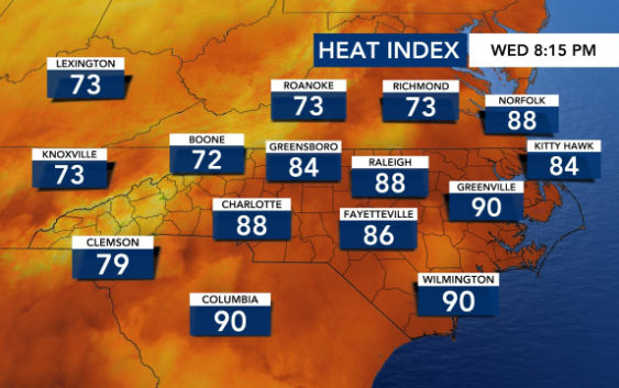
Temperatures will stay hot all week, but with highs in the upper 80s to low 90s, they won’t be as steamy as they were in July. The heat index will be in the mid 90s, making it feel hotter than it really is, but heat advisories and triple-digit heat indexes won’t be an issue like last week.
The month of August is forecast to have above-normal temperatures, and Gardner said more 90s are on the way.
