- Families of campers, counselors who died in Texas Hill County floods sue Camp Mystic
- Small plane bound for Jamaica with hurricane relief supplies crashes in Florida neighborhood
- Ask the Meteorologist: Did a tornado hit Johnston County Saturday night?
- Demolition begins on flood-damaged homes in Stoney Creek as neighbors await relief
- NC Office of State Fire Marshal aiding in Hurricane Melissa relief efforts
Forecast: Heavy rain tonight could cause flooding
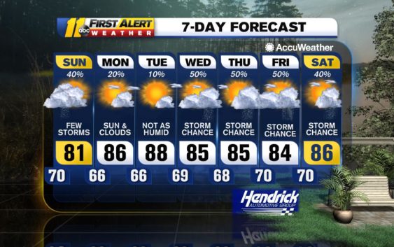
RALEIGH, N.C. (WTVD) — Low pressure over upstate South Carolina tracking to the east-northeast will cross the Triangle tonight causing showers and thunderstorms and the juicy air in place will lead to some locations receiving flooding downpours.
Low pressure will move away to the northeast tomorrow causing clouds and a lingering shower and it will be quite cool for this time of year with clouds breaking later in the afternoon. Drier air will move in from the northwest tomorrow night with patchy clouds and there will be areas of fog that develop overnight and linger into early Monday morning.
Otherwise on Monday, a weak cool front and upper trough will approach from the northwest and it will get milder with clouds and sun and there can be an afternoon shower or thunderstorm in parts of the area, but much of the time will be rain-free.
The front will reach the Appalachians on Tuesday and then cross the Triangle on Wednesday. It will be warmer on Tuesday with sunshine and building clouds and a possible afternoon shower or thunderstorm, then expect more in the way of clouds and more humid conditions with more numerous showers and thunderstorms on Wednesday.
The weather pattern will get stuck again later next week as the front stalls nearby and a slow moving upper level trough of low pressure crosses the Tennessee Valley into the Appalachians. Clouds will win out over sun both Thursday and Friday and there will be mainly afternoon and evening showers and thunderstorms around.
Be Well & Stay Safe!
Robert Johnson
Copyright © 2020 WTVD-TV. All Rights Reserved.