- Town of Wrightsville Beach preparing for coastal flooding this weekend
- Man charged with sparking the most destructive wildfire in Los Angeles history
- Carolina Hurricanes start 2025-26 season hosting New Jersey Devils
- Speedy Sparks, bassist for Texas Tornados, other San Antonio music icons, has died
- Authorities make an arrest related to deadly January wildfire that leveled LA neighborhood
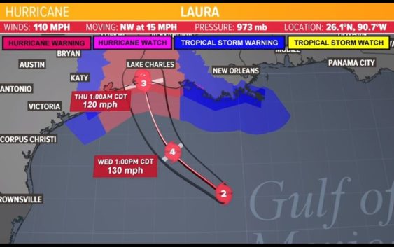
Houston Forecast: Tracking Hurricane Laura
HOUSTON — We are expecting summer-like conditions in Houston over the next several days: hot temperatures, high humidity with a slight chance for scattered showers.
As of the latest tropical update (early Wednesday morning), Hurricane Laura is heading east of Houston closer to the Texas-Louisiana border, which means we could get minimal impacts here from the storm. Storm surge in low-lying ares will be the greatest concern.
At this time we have technically have a high chance for rain on Wednesday and Thursday, but this could greatly change depending on where Laura makes landfall. With its current forecast track, the rain chances will likely go down for us in Houston with the Beaumont and Lake Charles areas bracing for the worst.