- Travis County is raising property taxes to pay for past and future floods
- Many ask where the hurricanes are this season as the Atlantic remains quiet
- Texas passed laws to address historic flooding. We asked a flood expert if they'll work.
- A city in Brunswick County is still repairing after Hurricane Florence
- Stein calls For $13.5 billion In new funding from Congress for Hurricane Helene Recovery
Flash Flood watch in effect Thursday, Friday
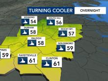
A flash flood watch is in effect for the Triangle and parts of North Carolina Thursday and Friday.
Hurricane Sally will cause a remnant low that will be south of North Carolina. The rain from this low will start to pick up for us Thursday.
Parts of the WRAL Viewing area are in most recent path of Hurricane Sally, but the most significant effects we will feel will be rain.
We are looking at getting 3 to 6 inches of rain over the next couple of days, according to WRAL meteorologist Elizabeth Gardner.
Some pockets of the WRAL Viewing area could get 8 inches of rain from Sally.
Thunderstorms should move out of our area by Friday night.
While Sally’s impact on the Gulf Coast could be severe, impacts in North Carolina will be minimal.
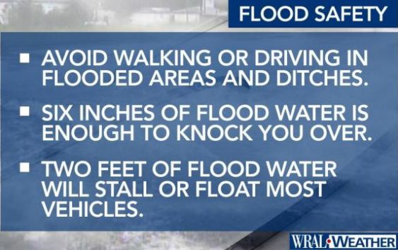
Since the weather is still nice outside for most of Wednesday, now is the time to start preparing for very heavy flooding.