- Man charged with sparking the most destructive wildfire in Los Angeles history
- Carolina Hurricanes start 2025-26 season hosting New Jersey Devils
- Speedy Sparks, bassist for Texas Tornados, other San Antonio music icons, has died
- Authorities make an arrest related to deadly January wildfire that leveled LA neighborhood
- AI simulation gives Carolina Hurricanes 20% chance to win 2026 Stanley Cup
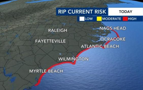
Hurricane Teddy bringing strong rip current risk to NC this week
The tropics remain extremely active this week after Hurricane Teddy brought heavy flooding to the Outer Banks over the weekend.
For only the second time in recorded history, all of the possible hurricane names have been used up this season, and we still have 10 weeks to go. We will now switch into using the Greek alphabet for names.
Tropical Storm Beta is in the Gulf of Mexico battling dry air and wind shear, which will limit its intensification. The storm is likely to move onshore and hug the coastline Monday evening. Texas and Louisiana are both at risk for flooding, with up to 15 inches of rain possible.
Teddy, now a Category 2 storm, will move east of Bermuda Monday afternoon. Tropical storm conditions will be possible for the island if the storm generates large swells. Life-threatening rip currents are possible along the East Coast this week, including in North Carolina.
If you are headed to the beach, make sure to swim near a life guard. If you do get caught in a rip current, don’t panic and swim parallel to the shore.
The remnants of Wilfred have now dissipated, and post-tropical cyclone Paulette will move over warm waters and eastward Monday. There is a 60% chance of development within the next two days.
In North Carolina, we could see remanent moisture from the storm and increased rain chances. We will likely feel this on Friday.