- Carolina Hurricanes start 2025-26 season hosting New Jersey Devils
- Speedy Sparks, bassist for Texas Tornados, other San Antonio music icons, has died
- Authorities make an arrest related to deadly January wildfire that leveled LA neighborhood
- AI simulation gives Carolina Hurricanes 20% chance to win 2026 Stanley Cup
- Warf steps down as president of Carolina Hurricanes
Hurricane Eta strengthens, could become major storm before landfall in Central America
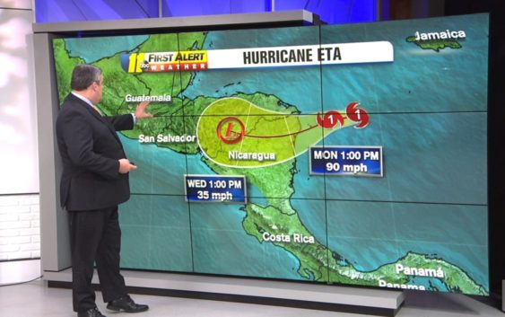
Hurricane Eta is rapidly strengthening in the Caribbean Sea and threatening to bring life-threatening storm surge, flash flooding, and landslides to Central America.
According to the National Hurricane Center, Eta has maximum sustained winds of 90 miles per hour. It is located 140 miles east of Honduras and Nicaragua and traveling west at 10 miles per hour.
Eta is expected to continuing strengthening. It could be a major storm by the time it makes landfall Tuesday.
Forecasters said central and northern Nicaragua into much of Honduras could get 15 to 25 inches of rain, with 35 inches in isolated areas.
After landfall, it’s quite unclear what Eta will do. The storm will undoubtedly weaken when it is over land, but the forecast models disagree on if it will continue west overland and fizzle out, or if it will turn north and enter the Gulf of Mexico where it could gain strength again.
Eta is the 28th named Atlantic storm this season, tying the 2005 record for named storms. However, this is the first time the Greek letter Eta is being used as a storm name because after the 2005 season ended, meteorologists went back and determined there had been a storm that should have gotten a name but didn’t.
Hurricane season still has a month to go, ending Nov. 30. And in 2005, the 28th named storm didn’t form until the end of December.
Historic hurricane season prompts question: Can we run out of Tropical Storm names?
Copyright © 2020 WTVD-TV. All Rights Reserved.