- Florence to begin interviewing police chief finalists in January
- A West Texas county wants to better prepare for floods. Paying for it will be tricky.
- They couldn’t save their daughters’ lives in the July 4 floods. Now they’re dealing with the grief and the guilt.
- Austin could see heavy rains, possible flooding over the next few days
- Families of campers, counselors who died in Texas Hill County floods sue Camp Mystic
Hurricane Iota now a Category 5 storm, forecast to bring extreme rain and life-threatening storm surge
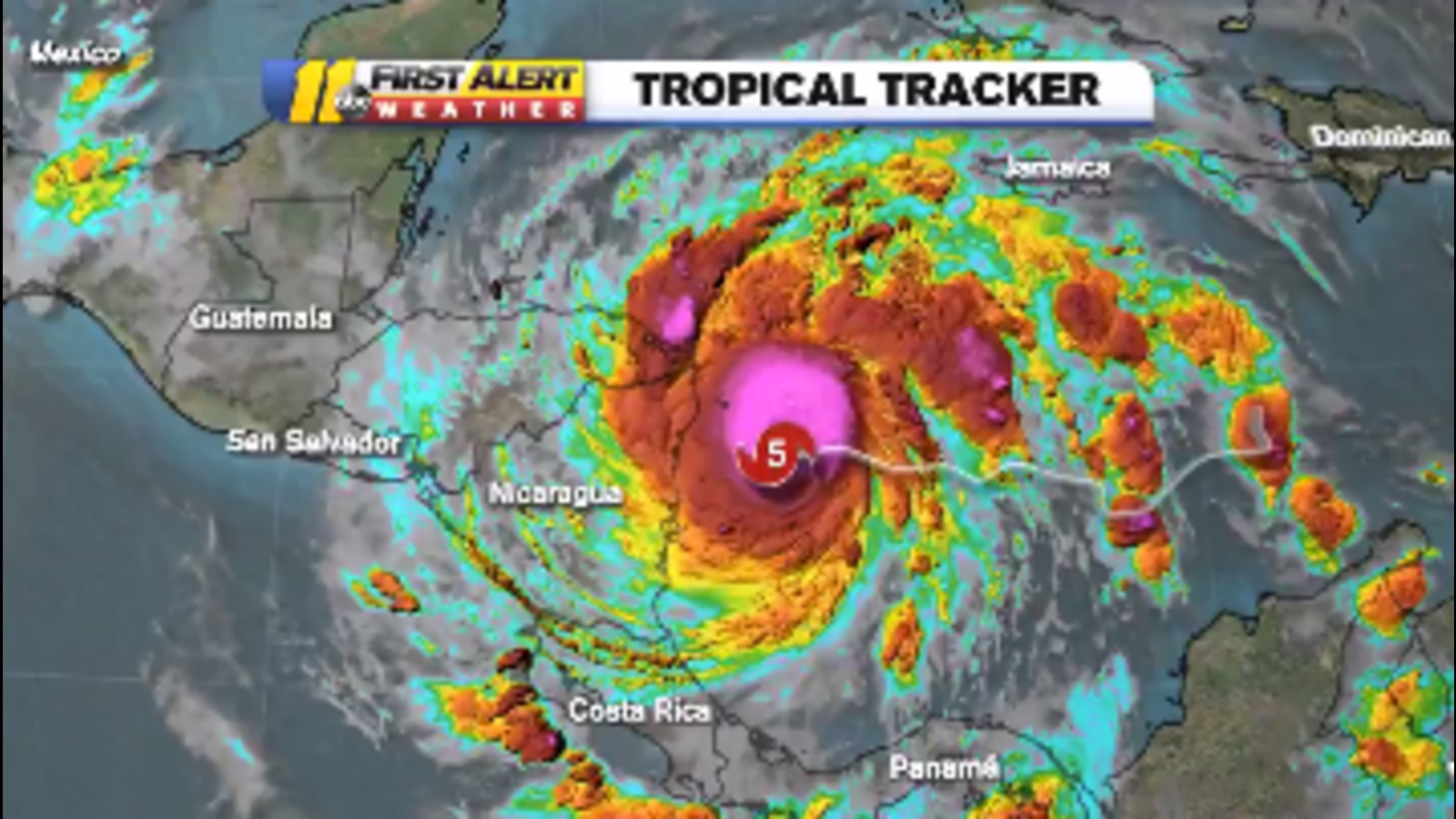
Hurricane Iota marks the latest chapter in a devastating hurricane season for Central America.
With the National Hurricane Center’s 10 a.m. EST update, Iota is now a Category 5 storm headed toward Nicaragua and Honduras. Iota is the 30th named storm of what’s been a record-breaking hurricane season.
Around 5 a.m., Iota was 25 miles northeast of Isla De Providencia, Colombia. The storm now has 165 mile-per-hour sustained winds, moving west at 9 miles per hour. Evacuations are underway in low-lying areas as a Tuesday landfall is likely.
Iota rapidly intensified overnight as it was a Category 2 storm just before 11 p.m. EST. The National Hurricane Center predicts the storm will bring potentially catastrophic winds, life-threatening storm surge and extreme rainfall. Flash flooding and mudslides are also likely.
Here are the 10 am EST Key Messages for category 5 Hurricane #Iota. Extreme winds and a life-threatening storm surge are expected along portions of the coast of northeastern Nicaragua. Life-threatening flash flooding is also expected in Central America. https://t.co/tW4KeFW0gB pic.twitter.com/CP5u0WQY5m
— National Hurricane Center (@NHC_Atlantic) November 16, 2020
Many of the spaghetti models have the system making landfall Tuesday morning and continuing west into the Pacific Ocean. Iota is not expected to impact the United States.
It was already a record-breaking system, being the 30th named storm of this year’s extraordinarily busy Atlantic hurricane season. Such activity has focused attention on climate change, which scientists say is causing wetter, stronger and more destructive storms.
In Honduras, compulsory evacuations began before the weekend and by Sunday evening 63,500 people were reported to be in 379 shelters just in the northern region, while the whole country was on high alert.
Nicaraguan officials said that by late Sunday afternoon about 1,500 people, nearly half of them children, had been evacuated from low-lying areas in the country’s northeast, including all the inhabitants of Cayo Misquitos. Authorities said 83,000 people in that region were in danger.
Wind and rain were beginning to be felt Sunday night in Bilwi, a coastal Nicaraguan city where people crowded markets and hardware stores during the day in search of plastic sheeting, nails and other materials to reinforce their homes, just as they did when Hurricane Eta hit on Nov. 3.
Several residents of Bilwi expressed concern that their homes would not stand up to Iota, so soon after Eta. Local television showed people being evacuated in wooden boats, carrying young children as well as dogs and chickens.
Authorities warned that the risk was high because Iota would probably come ashore over areas where Eta’s torrential rains left the soil saturated with water and more prone to new landslides and floods.
Eta already wreaked havoc. It hit Nicaragua as a Category 4 hurricane, killing at least 120 people as torrential rains caused flash floods and mudslides in parts of Central America and Mexico. Then it meandered across Cuba, the Florida Keys and around the Gulf of Mexico before slogging ashore again near Cedar Key, Florida, and dashing across Florida and the Carolinas.
Iota was forecast to drop 8 to 16 inches (200-400 millimeters) of rain in northern Nicaragua, Honduras, Guatemala and southern Belize, with as much as 30 inches (750 millimeters) in isolated spots. Costa Rica and Panama could also experience heavy rain and possible flooding, the hurricane center said.
Eta was the 28th named storm of this year’s hurricane season, tying the 2005 record for named storms. Theta, the 29th, was far out in the eastern Atlantic Ocean, and became a remnant low Sunday.
The official end of hurricane season is Nov. 30.
Copyright © 2020 WTVD-TV. All Rights Reserved.