- AI simulation gives Carolina Hurricanes 20% chance to win 2026 Stanley Cup
- Warf steps down as president of Carolina Hurricanes
- Tornado in North Dakota was the first at EF5 strength in a dozen years
- Eric Tulsky comfortable, confident and going for the Stanley Cup in 2nd year as Hurricanes GM
- 5 homes collapse into the surf of the Outer Banks as hurricanes rumble in Atlantic
Strong, quick-moving thunderstorm triggers multiple Tornado Warnings in central NC
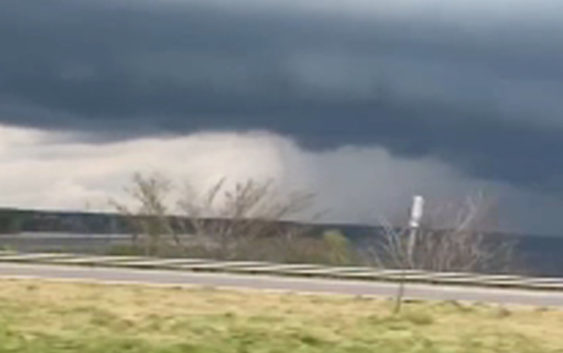
A strong and quick-moving storm triggered multiple Tornado Warnings in eight counties across central North Carolina on Saturday evening.
From around 4:40 p.m. to 7:30 p.m. tornado warnings were in effect for many central North Carolina counties including: Wake, Johnston, Wilson, Wayne, Nash, Lee, Harnett and Moore counties.
The tornado warning has expired. That same storm is now under a severe thunderstorm warning for southern Nash, southern Edgecombe, and Wilson county until 6:45pm. This storm is moving east at 30mph. It could produce small hail, and up to 60mph winds. pic.twitter.com/VeywfuwQQ4
— Brittany Bell (@BrittanyABC11) March 27, 2021
If you weren’t under a Tornado Warning, you were at least under a Severe Thunderstorm Warning until 8 p.m. The main threat for these regions are damaging winds and large hail.
After 8 p.m., Meteorologist Robert Johnson said to expect a warm and cloudy night with patchy fog developing — but not as heavy as this morning.
What are straight-line winds and how do they form
As a potent low-pressure system passes through the Northeast Sunday, a cold front tied to the system will sweep across the Southeast and Mid-Atlantic Sunday night into Monday. This is expected to bring another round of rain and gusty thunderstorms. Around the Triangle, damaging winds will be a possible threat.
Copyright © 2021 WTVD-TV. All Rights Reserved.