- AI simulation gives Carolina Hurricanes 20% chance to win 2026 Stanley Cup
- Warf steps down as president of Carolina Hurricanes
- Tornado in North Dakota was the first at EF5 strength in a dozen years
- Eric Tulsky comfortable, confident and going for the Stanley Cup in 2nd year as Hurricanes GM
- 5 homes collapse into the surf of the Outer Banks as hurricanes rumble in Atlantic
Severe weather risk increased to level 2 for part of central North Carolina
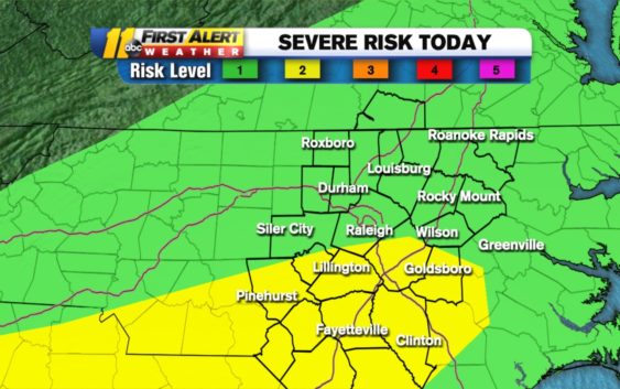
RALEIGH, N.C. (WTVD) — Severe weather is possible in central North Carolina today.
Those storms are more likely in the southern part of the region. The National Weather Service has the Sandhills in a level 2 risk for severe weather, with the rest of the region being under a level 1 risk.
While you were sleeping, the @NWSSPC upgraded the Sandhills to a Cat 2 of 5 risk for severe weather. Biggest threat=damaging wind. Could also see hail or an isol. tornado. Timing=late afternoon & evening. #ncwx #WYWS pic.twitter.com/3Ak0nLOZB4
— 𝘿𝙤𝙣 𝙎𝙘𝙝𝙬𝙚𝙣𝙣𝙚𝙠𝙚𝙧 (@BigweatherABC11) March 31, 2021
Damaging winds are the biggest threat with these storms. However, an isolated pocket of hail or an isolated tornado are also possible.
TIMELINE
A scattered shower or two could pop up anytime ahead of 1 p.m. Wednesday.
The main line of storms is pacing to arrive in central North Carolina around 5 p.m. The strongest storms could remain in the region through 10 p.m.
As the storms move out, showers will likely linger into Thursday morning. Everywhere should be dry before noon.
Temperatures will be much cooler Thursday, and it will be breezy.
The cooler temperatures will last through Friday night. There’s even a chance for a frost advisory for Thursday and Friday night, as temperatures will likely drop below 32 degrees.
But don’t worry, spring temperatures will return for the weekend. Highs should be back above 70 for Easter Sunday, and mid 70s will return next week.
Copyright © 2021 WTVD-TV. All Rights Reserved.