- Families of campers, counselors who died in Texas Hill County floods sue Camp Mystic
- Small plane bound for Jamaica with hurricane relief supplies crashes in Florida neighborhood
- Ask the Meteorologist: Did a tornado hit Johnston County Saturday night?
- Demolition begins on flood-damaged homes in Stoney Creek as neighbors await relief
- NC Office of State Fire Marshal aiding in Hurricane Melissa relief efforts
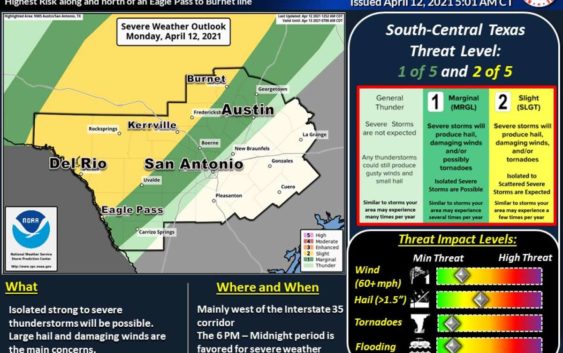
San Antonio area could see severe weather including hail and damaging winds

There is a marginal risk for severe weather in the San Antonio area Monday evening.
National Weather Service
Rain chances will continue for the rest of the week as a cold front arrives in the area.
National Weather Service
San Antonio will see a high close to 90 degrees, forecasters say.
National Weather Service
The San Antonio area could see severe weather Monday evening, according to the National Weather Service.
As of Monday morning, parts of San Antonio are under a marginal risk for severe storms. The NWS says that means there is a chance severe storms will produce hail, damaging winds, and/or possibly tornadoes.
READ ALSO: ‘Line of stars’ spotted in San Antonio sky creates buzz online
The main threats to severe weather will be west of the Interstate 35 corridor and the Hill Country. Forecasters also say between 6 p.m. and midnight is when they expect the storms to arrive.
The storms are a result of a cold front coming through the area and will stick around for a few days. Chances of rain will continue through Friday. Temperatures will remain mild with highs in the 70s.