- AI simulation gives Carolina Hurricanes 20% chance to win 2026 Stanley Cup
- Warf steps down as president of Carolina Hurricanes
- Tornado in North Dakota was the first at EF5 strength in a dozen years
- Eric Tulsky comfortable, confident and going for the Stanley Cup in 2nd year as Hurricanes GM
- 5 homes collapse into the surf of the Outer Banks as hurricanes rumble in Atlantic
Risk for severe weather canceled; Sunday will bring nicer weather
We’re experienced a soggy start to the weekend on Saturday, but the Triangle has escaped the risk of severe storms.
Temperatures started out chilly, with temps in the 40s and even in the 30s in some areas north of the Triangle, but warmed gradually throughout the afternoon. Most of the WRAL viewing area saw a fair amount of rain throughout the day.
The potential for storms depended on a warm front that was approaching from the south; however, the front stayed out of North Carolina, leaving us with a cool, stable atmosphere.
The Triangle is about 1.5 inches below the average rainfall amount for April. This is the sixth driest April to date on record at RDU.
Overnight, we’ll dry out.
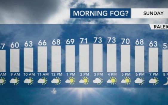
Sunday will be a much better day to get outside. We’ll be partly cloudy with highs in the low 70s.
WRAL meteorologist Zach Maloch says that we may see some cloud cover for a majority of the day, but the sun should take over by the middle of the afternoon.
“By around 3 to 4 p.m., that’s when those clouds start to erode away, and we’ll see the sunshine. Perfect for heading outdoors,” Maloch said.
Maloch says our southern counties could see highs reaching 75 degrees Sunday.

Next week, we’re expected to warm up with highs in the mid 80s.
“Sunshine will be in full force Monday afternoon,” Maloch said, as temps are expected to reach the upper 70s, with minimal cloud cover.
