- Authorities make an arrest related to deadly January wildfire that leveled LA neighborhood
- AI simulation gives Carolina Hurricanes 20% chance to win 2026 Stanley Cup
- Warf steps down as president of Carolina Hurricanes
- Tornado in North Dakota was the first at EF5 strength in a dozen years
- Eric Tulsky comfortable, confident and going for the Stanley Cup in 2nd year as Hurricanes GM
TIMELINE: Flash Flood Watch remains in effect as more rain moves in
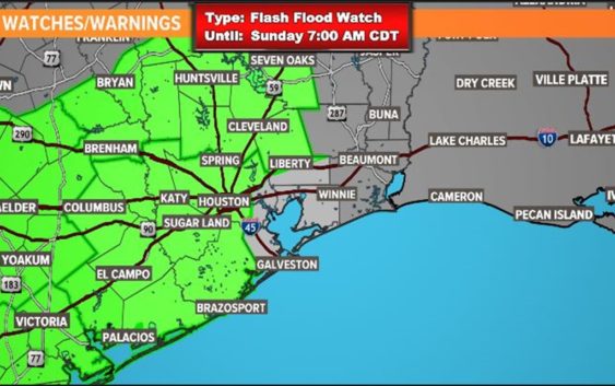
HOUSTON — The National Weather Service still has the Houston area under a Flash Flood Watch through Sunday morning at 7 a.m.
The areas under a Flash Flood Watch until Sunday morning include the following counties/areas covering a portion of Southeast Texas: Austin, Bolivar Peninsula, Brazoria Islands, Chambers, Coastal Brazoria, Coastal Galveston, Coastal Harris, Coastal Matagorda, Colorado, Fort Bend, Galveston Island, Inland Brazoria, Inland Galveston, Inland Harris, Inland Matagorda, Matagorda Islands, Southern Liberty, Waller and Wharton.
SATURDAY: Our next round of potentially heavy rain arrived before sunrise. An additional 1″ to 3″ of rain is possible in the heavier downpours. After that, there will be a lull in heavy rains midday, but another round of showers/storms moves in later this afternoon.
SATURDAY NIGHT: Another round of storms is expected to move across the area from west to east roughly around 10 PM. Rainfall could be quite heavy, but this line of storms is forecast to be moving fairly quickly. Fingers are crossed that it will move through without causing too much trouble. However, we could see an additional 1″ to 3″ with this round and with saturated grounds in place. Flash flooding will be a concern.
SUNDAY: A few lingering scattered showers through the morning. Then, improving conditions, maybe a peek of sunshine by late afternoon.
NEXT WEEK: We’ll finally start to see some sunshine come Monday as temps heat up to about 90 degrees.
We are 6+ inches behind in our rainfall. So all this rain will be beneficial in tamping down the expanding drought conditions across Southeast Texas.