- AI simulation gives Carolina Hurricanes 20% chance to win 2026 Stanley Cup
- Warf steps down as president of Carolina Hurricanes
- Tornado in North Dakota was the first at EF5 strength in a dozen years
- Eric Tulsky comfortable, confident and going for the Stanley Cup in 2nd year as Hurricanes GM
- 5 homes collapse into the surf of the Outer Banks as hurricanes rumble in Atlantic
NC Weather: Severe weather risk at level 1 and 2 for central North Carolina
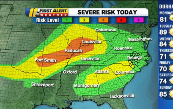
RALEIGH, N.C. (WTVD) — This week starts with a chance for severe weather across central North Carolina.
The National Weather Service has all of the region in a level one threat for severe storms, with the southernmost area–Moore, Hope, Robeson counties–being under a level two risk.
While you were sleeping, the @NWSSPC increased the risk to a Cat 2 of 5 in the SW portion of the @ABC11_WTVD viewing area. Rest of region under at Cat 1. Biggest threat=damaging winds with any storms that get rolling. #NCWX pic.twitter.com/kIoFe6Subu
— 𝘿𝙤𝙣 𝙎𝙘𝙝𝙬𝙚𝙣𝙣𝙚𝙠𝙚𝙧 (@BigweatherABC11) May 3, 2021
There is a 60 percent chance of storms developing. If they do develop in your area, they could be severe with the highest threat being damaging wind. There’s a lower risk the storms could spawn an isolated tornado or hail.
“The bulk of the storms will pass through Virginia, but as it draws up this moisture into us, that’s were it could bring us that chance of thunderstorms,” ABC11 Meteorologist Don “Big Weather” Schwenneker said.
The best chance for storms is between 2 and 5 p.m.
Click here for the latest weather forecast.
Temperatures Monday will reach into the 80s. Tuesday will be the hottest day of the week with temperatures peaking into the 90s.
Another chance for storms arrives Wednesday.
The Mother’s Day weekend is looking dry with temperatures in the 70s and 80s.
Copyright © 2021 WTVD-TV. All Rights Reserved.