- AI simulation gives Carolina Hurricanes 20% chance to win 2026 Stanley Cup
- Warf steps down as president of Carolina Hurricanes
- Tornado in North Dakota was the first at EF5 strength in a dozen years
- Eric Tulsky comfortable, confident and going for the Stanley Cup in 2nd year as Hurricanes GM
- 5 homes collapse into the surf of the Outer Banks as hurricanes rumble in Atlantic
Central, eastern NC now under level 2 threat for severe weather
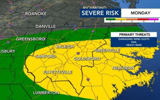
After a weekend of celebrations and nice weather, a chance for showers and storms returns Monday.
The threat for severe weather in the WRAL viewing area grew overnight, and part of the Triangle is now in the level 2 risk area. The level 2 threat is also in effect for Fayetteville and much of the Sandhills region.
“Some showers may be possible for the morning commute,” WRAL meteorologist Zach Maloch said, adding that it will be a warm and humid morning.
“Damaging winds will be the main threat, but hail is also a possibility,” Maloch said.
Maloch says midday Monday we should see a slight break in rain coverage with the sun popping out slightly. Temperatures will climb into the mid-to-upper 70s.
The storms are likely to arrive in the afternoon. Maloch says they’ll begin to pop up after 1 p.m. and can increase in coverage and intensity through the evening commute.


“Damaging winds are possible, but so is some large hail due to the freezing level height,” Maloch said. “If storms can get tall enough and tap into the freezing level we may get larger hail than what we saw last Friday.”
Rain and storms will continue into the evening into the Sandhills before things quiet down after 10 p.m.
We’ll be drier Tuesday for the Durham Bulls Opening Day coverage. No problems there! Isolated rain chances will be rather sporadic Wednesday to Friday and are dependent on the strength of an area of high pressure as that can keep a lot of that rain south.