- Carolina Hurricanes start 2025-26 season hosting New Jersey Devils
- Speedy Sparks, bassist for Texas Tornados, other San Antonio music icons, has died
- Authorities make an arrest related to deadly January wildfire that leveled LA neighborhood
- AI simulation gives Carolina Hurricanes 20% chance to win 2026 Stanley Cup
- Warf steps down as president of Carolina Hurricanes
Flash Flood Watch expires for Houston area
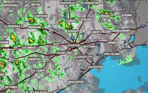
We could see more flash flooding today as rain pops up in the early afternoon hours — watch KHOU 11 News.
HOUSTON — A Flash Flood Watch for the Houston area has been allowed to expire at 7 p.m.
However, the chance for rain will return Wednesday morning.
Rain chances remain high but drop down to about 50 percent compared to what we saw on Tuesday.
We will see some scattered showers pop up through the morning.
Tuesday was another day of heavy downpours around the Houston area, but fortunately, we avoided any major flooding.
Some parts of town yesterday got more than 7″ of rain, especially on the city’s northeast side. And on the south side, flooding was reported along Highway 288. Thankfully, the high water spots there and on I-45 have since receded.
Will it rain for Memorial Day weekend?
By Wednesday, rain chances drop down to about 50 percent.
However, after a few days without rain, a front could bring some showers to our area in time for the holiday weekend.
Right now there is a slight chance for rain beginning with 30% on Saturday.
Images from Monday’s flooding
As the ran fell, we saw plenty of photos and videos of high water, including this scene from Atascocita, where one person had to be rescued.
And Twitter user @PastorJaimeG captured these two videos of driving in high water. First, video from northeast Houston…
And going back to Atascocita, Barbara sent these photos showing the high water there.