- AI simulation gives Carolina Hurricanes 20% chance to win 2026 Stanley Cup
- Warf steps down as president of Carolina Hurricanes
- Tornado in North Dakota was the first at EF5 strength in a dozen years
- Eric Tulsky comfortable, confident and going for the Stanley Cup in 2nd year as Hurricanes GM
- 5 homes collapse into the surf of the Outer Banks as hurricanes rumble in Atlantic
Slow-moving, heavy rain could bring flooding to the Triangle
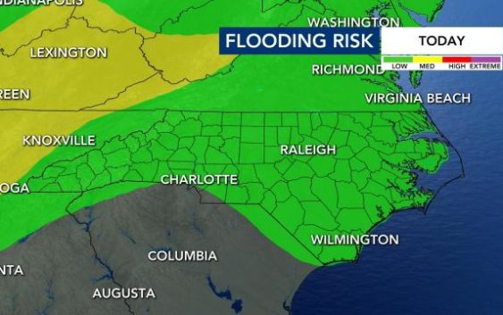
Raleigh, N.C. — A great deal of moisture flowing into North Carolina from the Gulf of Mexico is setting the stage for some heavy rainfall in the coming days. Tropical moisture will continue to stream in from the Atlantic and storms could tap into that moisture and produce heavy rain.
“All we need now is a trigger to develop the rain and that trigger will be the low pressure system moving in later this week,” said WRAL meteorologist Mike Maze.
Wednesday will have a 30 percent chance for rain. We’re looking at another mild, muggy and dry morning followed by a warm afternoon. Scattered showers and thunderstorms will develop after 2 p.m.
“Our storms will be fairly slow-moving [Wednesday],” said WRAL meteorologist Elizabeth Gardner. “That means that we could see some heavy rain. We do have a flash-flooding risk. It’s a low risk, but it’s not a zero risk.”
The best chances for rain will come in the evening. Highs will top out in the upper 80s.

“Some of the rain Wednesday night could be on the heavy side,” said Maze.
The rain is expected to pick up around 10 p.m. and could continue until the early morning hours on Thursday, according to WRAL meteorologist Aimee Wilmoth.
Rain chances will continue to increase as the week goes on with Thursday having a 40 percent chance for rain.
Wednesday and Thursday feature a low risk of flooding, according to Maze, so any of the showers and storms the next two days could trigger flood advisories since the rain could be heavy at times.

“I think the day that has the best chance for that is Friday, when that system is directly over us,” said Maze.
The Triangle and points to the north and east are under a medium risk for flash flooding on Friday, when widespread rain is expected.
The 5-day rainfall total shows many locations in central North Carolina could see 1-2 inches of rain.
Friday and Saturday will then have a 50 percent chance for storms.
Temperatures will remain in the upper 80s for the work week, before dipping into the low 80s on Saturday.

After the driest spring on record, the state is set up for soaking conditions this week.
It was a wet start to the month, with 3.8 inches of rain recorded at Raleigh-Durham International Airport so far in June.
“The June average is 3.89, so we’re almost there already — just four days in,” said WRAL meteorologist Kat Campbell.
While Raleigh received about 2.4 inches of rain over the past week, other towns such as Greensboro received upwards of 6 inches of rain.
