- U.S.-based aid groups rush to get supplies into storm-battered Jamaica after Hurricane Melissa
- Travelers stuck in Jamaica due to Hurricane Mellissa forced to pay for unwanted extended stay
- Raleigh police officer awaits word from family in Jamaica after Hurricane Melissa devastation
- North Carolina’s leaders give insight on the effects of Hurricane Melissa
- ‘We want some answers;’ Whiteville residents demand city response to prevent flooding
Flash flood watch expires at midnight, but additional rain possible overnight
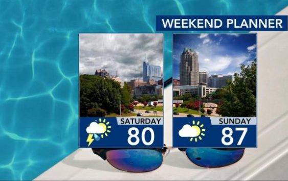
Raleigh, N.C. — Storms are possible through the evening and into the early hours of Saturday, and pockets of heavy rain are possible, WRAL meteorologist Aimee Wilmoth said. Northeast counties are under a flash flood watch through the evening, she said.
A chance for showers and thunderstorms will remain in place overnight, before kicking off an overcast Saturday.
“But, not a bad weekend ahead,” said WRAL meteorologist Mike Maze.
Maze said by the end of the day Saturday, there could be a little bit of sunshine.
Because of the cloud coverage, temperatures will be in the upper 70s.
There will also be a 40 percent chance for light rain on Saturday, according to Maze.
“I think most of it will end up being in the southern counties,” he added.
It will warm back up on Sunday, with temperatures in the upper 80s.
‘It’s less humid and no rain,” said Maze.
If you’re heading to the beach this weekend, you might want to have a backup plan for some indoor plans. Saturday and Sunday both have a chance for scattered storms and a moderate risk for rip currents down east of the caost, according to Maze.
Temperatures will pick back up next week, with highs in the low 80s and upper 90s and small chances for rain.

Meteorologists also are keeping an eye on a system in the Pacific, Wilmoth said. If it crosses the Bay of Campeche and emerges in the Gulf of Mexico on Sunday, it has a 20 percent chance to develop into a tropical system in the following five days.