- Austin and Travis County issue disaster declaration as wildfire risk rises
- Raleigh rethinks how to grow as flooding, heat and traffic worsen
- New legislative panels will investigate ‘facts and circumstances’ of deadly Central Texas floods
- Heavy rain floods downtown Whiteville forcing local businesses to deal with damage again
- New legislative panels will investigate “facts and circumstances” of deadly Central Texas floods
NC weather: Winds, hail, tornado possible with elevated severe storm risk today
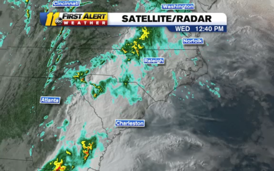
RALEIGH, N.C. (WTVD) — Severe weather is possible in central North Carolina on Wednesday.
The weather system that brought tornadoes to Texas and Louisiana is pushing into North Carolina.
The National Weather Service has placed the region under a level 2 of 5 risk for severe storms. The storms could include damaging winds, hail and even isolated tornadoes.
TIMING
Scattered showers could begin around noon. However, the strongest storms will not arrive until a little bit later.
You can expect the worst weather to happen between 2-10 p.m.
Any slow moving storms could cause flooding in low-lying areas.
While the bulk of the storms will move out Wednesday night, some could linger into Thursday. By Thursday afternoon, all of the storms should have moved out of the area and toward the coast.
Temperature-wise, Wednesday and Thursday will see highs in the upper 60s and low 70s for most of the area.
WATCH: How you can prepare for severe weather and stay safe
Copyright © 2022 WTVD-TV. All Rights Reserved.