- NC Office of State Fire Marshal aiding in Hurricane Melissa relief efforts
- U.S.-based aid groups rush to get supplies into storm-battered Jamaica after Hurricane Melissa
- Travelers stuck in Jamaica due to Hurricane Mellissa forced to pay for unwanted extended stay
- Raleigh police officer awaits word from family in Jamaica after Hurricane Melissa devastation
- North Carolina’s leaders give insight on the effects of Hurricane Melissa
Severe weather threat for North Texas tonight and Tuesday
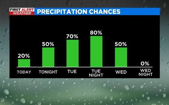
NORTH TEXAS (CBSDFW.COM) – Warm, humid air is quickly on the return as a warm front lifts in from south Texas over the next 24 hours. With it comes the chance for scattered thunderstorms starting late tonight and continuing through the day on Tuesday.
While it won’t be raining everywhere all day, a large portion of North Texas will see rain tomorrow-tomorrow night. Showers and storms will gradually exit to the east on Wednesday as the cold front swings through.
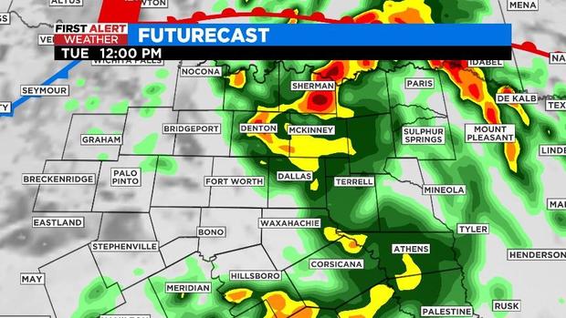
The best chance for the Metroplex to see widespread rain and the potential for severe weather will be on Tuesday evening. Damaging winds and large hail appear to be the primary threats throughout North Texas.
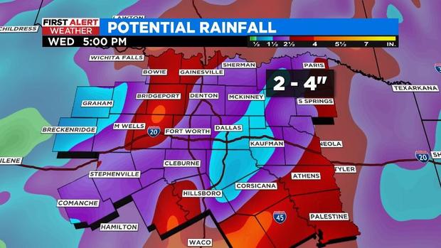
With the ongoing drought, several days of on again, off again rain isn’t such a bad thing. Widespread totals of 2″ to 4″ of rain are anticipated now through Wednesday.
Have a wonderful week and hold off getting the car washed!