- Warf steps down as president of Carolina Hurricanes
- Tornado in North Dakota was the first at EF5 strength in a dozen years
- Eric Tulsky comfortable, confident and going for the Stanley Cup in 2nd year as Hurricanes GM
- 5 homes collapse into the surf of the Outer Banks as hurricanes rumble in Atlantic
- As hurricanes pass offshore, more Buxton homes collapse into the sea
Tropical Storm Alex will begin weakening, high rip current risk remains at NC coast
The latest updates on Tropical Storm Alex:
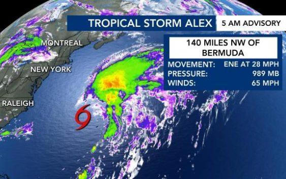
Monday, 5 a.m.
Tropical Storm Alex will begin weakening as it moves past Bermuda on Monday.
Alex, which became the first named storm of the 2022 Atlantic hurricane season Sunday in the 2 a.m. advisory from the National Hurricane Center, is moving straight into the wide open Atlantic, where it will fall apart in cooler waters, WRAL meteorologist Elizabeth Gardner said.
Alex will likely become a low pressure system sometime Monday afternoon or on Tuesday, but there will be a high rip current risk at North Carolina beaches until Wednesday, Gardner said.
Tropical storm watches are in place for Bermuda on Monday, as Alex could produce strong winds and drop heavy rain on the area.
The cyclone formed in the Atlantic last week and was expected to develop into a tropical storm on Friday. Conditions in the atmosphere Saturday were no longer favoring a tropical storm, and as the system moved closer toward Florida, it began to weaken.

However, Alex reached tropical storm force after strengthening off Florida’s east coast early Sunday.
For North Carolina, although the storm is well offshore, most beaches are under high or moderate rip current danger.
2 dead in Cuba
Alex had a significant impact on Cuba. Heavy rains caused landslides that killed two people.
The storm also threatened the future of this year’s tobacco crop and dumped buckets of rain on Florida, even without its tropical storm status.
Early in the week, meteorologists saw a more defined center of circulation. Winds were at 40 miles per hour on Thursday — and they need to be at 39 mph or higher with a clearly defined center of circulation to become an official tropical storm.
But by Saturday, the storm had fallen apart, and it was no longer looking like a system that would form into a tropical storm. Winds were still moving at 40 miles per hour on Saturday.

Moisture from the storm could interact with a frontal boundary, bringing showers and storms to North Carolina’s southern coast Sunday.
The latest report on this year’s hurricane season predicts another above-average number of storms will form in the Atlantic Ocean.
Experts in North Carolina say the report comes as climate change is creating more powerful hurricanes and making their behavior more dangerous as well.
Researchers expect 19 named storms and four major hurricanes to form in the north Atlantic from June to November.