- Carolina Beach is warning of potential King Tide flooding
- NCDEQ launches Hurricane Helene recovery grants program
- Why no hurricanes made landfall in the US in 2025
- Florence to begin interviewing police chief finalists in January
- A West Texas county wants to better prepare for floods. Paying for it will be tricky.
TIMELINE: Flood Watch issued for northern Houston-area counties until Tuesday night
The KHOU 11 Weather Team said the heaviest rain is expected Tuesday morning and it could impact the morning commute.
HOUSTON — Another round of heavy rain is expected across the Houston area early Tuesday morning.
The heaviest of the rain and greatest flooding potential will likely come during the Tuesday morning commute and could potentially last into the early afternoon.
Active weather alerts
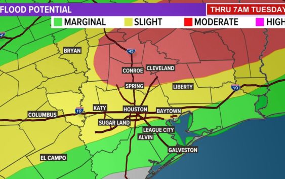
- A Flood Watch is in effect for Washington, Grimes, Walker, San Jacinto, Montgomery and Polk counties through Tuesday.
Watch the latest update from Chief Meteorologist David Paul below:
Rain Timeline
5 a.m. Tuesday: The boundary settles into the Houston area and will begin to trigger storms.
7 a.m.: Storms continue to build with heavy downpours slowly moving along the boundary. Morning commuters will likely be impacted by this round of rain.
9 a.m.: Downpours continue and look to impact most areas along and south of I-10.
Here is a look at the potential flooding impact of Tuesday’s severe weather:
Check interactive Houston-area radar
Follow the KHOU 11 Weather Team for daily updates: