- A West Texas county wants to better prepare for floods. Paying for it will be tricky.
- They couldn’t save their daughters’ lives in the July 4 floods. Now they’re dealing with the grief and the guilt.
- Austin could see heavy rains, possible flooding over the next few days
- Families of campers, counselors who died in Texas Hill County floods sue Camp Mystic
- Small plane bound for Jamaica with hurricane relief supplies crashes in Florida neighborhood
Level 1 risk: Isolated tornado, strong winds possible with Wednesday storms
RALEIGH, N.C. — Scattered showers will be possible Wednesday morning, especially in northern counties, before severe weather impacts the Triangle this afternoon.
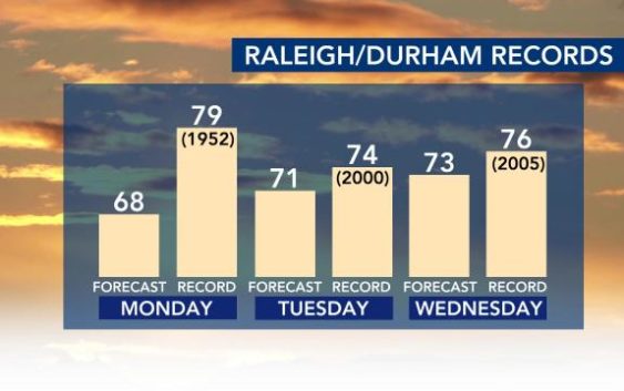
Wednesday will be rainy but very warm, with highs expected to reach the low 70s. Wednesday’s high of 73 degrees will be close to the Jan. 4, 2005, record of 76 degrees.

The area is under a Level 1 risk for severe weather. Heavy rain, gusty winds and an isolated tornado will be possible.
The afternoon and evening commute will be stormy Wednesday. A line of storms will move through from about noon to 5 p.m. Some storms could be strong to severe, but damaging winds will be the main threat.
“We’re going to see a better chance for thunderstorms around lunchtime,” WRAL meteorologist Elizabeth Gardner said.

According to Gardner, the majority of the storms should be gone by the evening commute.
Early-morning clouds will give way to a sunny afternoon Thursday, with a high of 66 degrees.

Thursday and the days following will be clearer and dry. A cold front will cause highs to fall into the 50s Friday and this weekend.

Related Topics
• Credits
Copyright 2023 by Capitol Broadcasting Company. All rights reserved. This material may not be published, broadcast, rewritten or redistributed.