- A West Texas county wants to better prepare for floods. Paying for it will be tricky.
- They couldn’t save their daughters’ lives in the July 4 floods. Now they’re dealing with the grief and the guilt.
- Austin could see heavy rains, possible flooding over the next few days
- Families of campers, counselors who died in Texas Hill County floods sue Camp Mystic
- Small plane bound for Jamaica with hurricane relief supplies crashes in Florida neighborhood
Live radar: Track storms moving through the Houston area, flash flood warning issued for Harris Co.
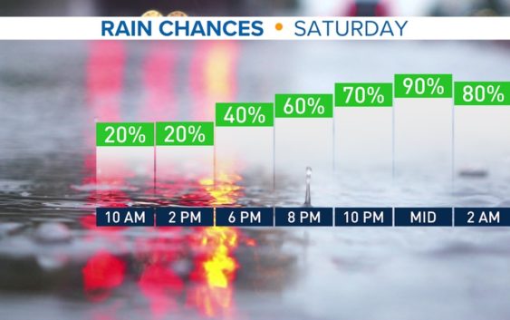
Rain and storms will develop by Saturday evening.
HOUSTON — The pollen count has nearly tripled from yesterday — ouch! However, things will feel better for those suffering from Cedar fever this weekend as incoming rain will help wash some of that away.
Temperature-wise, we’re in for one more day in the upper 70s. The record high is 79, which we’ll near before the front moves in and cools us back down into the 60s momentarily.
A slow-moving cold front approaches Saturday evening and rain chances go up from there.
Periods of rain, heavy at times are expected Saturday evening into early Sunday as the front moves through. The main front sets up around the 9 PM hour and pushes to the coast by early morning Sunday.
A few thunderstorms and heavy downpours are possible until about 10 AM Sunday.
Aside from a lingering shower early Monday morning, the unsettled weather will clear out for the middle of the week. By the end of it, another disturbance looks to bring back rain chances late Thursday. If you like the winter warmth we’re having, you’re in luck! It looks to continue through the middle of January.
Follow the KHOU 11 Weather Team for the latest updates on the forecast: