- Carolina Beach is warning of potential King Tide flooding
- NCDEQ launches Hurricane Helene recovery grants program
- Why no hurricanes made landfall in the US in 2025
- Florence to begin interviewing police chief finalists in January
- A West Texas county wants to better prepare for floods. Paying for it will be tricky.
Another round of storms Tuesday could bring hail, damaging winds
Discreet cells could create large hail on Tuesday afternoon.
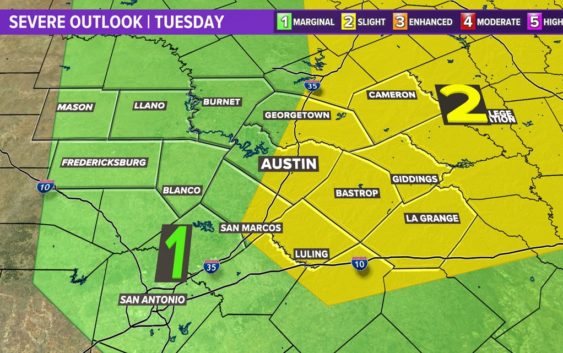
AUSTIN, Texas — We’ve had a cooler afternoon on Sunday after Saturday night’s stronger storms in the Hill Country, but we have another good chance for scattered storms for Tuesday afternoon in the Coastal Plains – although anywhere in Central Texas is fair game for severe weather on Tuesday. With this in mind, let’s break down the timing and threats for Tuesday’s storm chances.
Threats
Most of the Coastal Plains are under a “slight” – 2 out of 5 – risk for severe weather according to the Storm Prediction Center, with the remainder of the region being in the “marginal” – 1 out of 5 – risk.
As for the main threats, we’re once again looking at large hail, with damaging winds being a secondary threat. A brief spin-up tornado is not out of the question, but this chance is very low.
Timing
For Tuesday, we expect to start off with maybe one to two isolated showers to start your morning, before a dry lull leading into the early afternoon.
It is Tuesday afternoon that we watch for the better chance for scattered storms generally east of Interstate 35, which could involve some discreet cells that produce large hail.
Afterwards, we expect this system to clear out as the instability drops throughout the overnight hours. However, we are also watching Wednesday night into Thursday, but we are too far out to give specific timing or the strength of those storms.
Stick with KVUE for the latest on this developing forecast.
In the meantime, your seven-day forecast is below.