- Carolina Beach is warning of potential King Tide flooding
- NCDEQ launches Hurricane Helene recovery grants program
- Why no hurricanes made landfall in the US in 2025
- Florence to begin interviewing police chief finalists in January
- A West Texas county wants to better prepare for floods. Paying for it will be tricky.
Tropical update: Idalia expected to 'rapidly intensify' into major hurricane
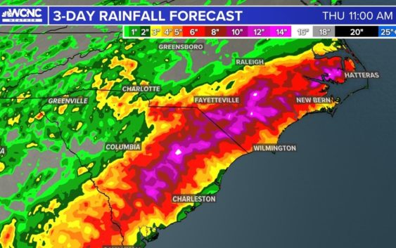
Idalia is expected to bring some impactful weather to the Carolinas later this week.
CHARLOTTE, N.C. —
Idalia update
Idalia (ee-DAL-ya) is quickly strengthening into a hurricane as the west coast of Florida braces for impact. The storm is expected to bring life-threatening storm surge and powerful winds to that area of Florida as early as Tuesday.
Idalia is expected to become the second major hurricane in the Atlantic Basin before it makes landfall on Wednesday morning near Florida’s Big Bend region.
Tropical Storm Idalia continues to intensify as it remains mostly stationary just southwest of Cuba. As it begins to move into the Gulf, it has the potential to go from a Category 1 to a Category 3 in less than 24 hours. Favorable conditions in the Gulf such as low wind shear and warm ocean temperatures near 90 degrees will support rapid intensification.
Idalia is moving north around 8 mph. A hurricane warning has been issued for the west coast of Florida on the Gulf Coast side of the peninsula. The region of the state could experience storm surge upwards of 11 feet along the Big Bend, and Tampa Bay could experience storm surge up to 9 feet.
The impacts from Idalia will be far reaching after landfall. Georgia, South Carolina and North Carolina are all preparing for flooding rainfall, tropical storm force winds and storm surge among other coastal impacts.
Expect some of the first outer bands of Idalia to reach North Carolina on Wednesday. The storm will make its closest approach to the Charlotte area late Wednesday as it passes to the east based on the latest data. Meanwhile, expect waves of heavy rainfall and localized flooding before the tropical system arrives between Wednesday and Thursday.
For the latest weather alerts, download the WCNC Charlotte mobile app and enable push notifications.
There’s still notable uncertainty with the track. Please stay tuned for updates from the WCNC Charlotte Weather Team.
Hurricane Franklin (First Category 4 hurricane of the season)
Franklin is not making the headlines since it will no affect land. It already crossed Hispaniola as a tropical storm but will not threaten land at its strongest. It just got done with its “rapid intensification” that Idalia will go through next. Franklin may be producing life-threatening surf and rip currents along the southeast coast.
This hurricane is officially the 130th documented category 4 hurricane and currently the strongest of the 2023 Atlantic Hurricane Season.
There’s still notable uncertainty with the track. Please stay tuned for updates from the WCNC Charlotte Weather Team.
Contact KJ Jacobs at kjacobs3@wcnc.com and follow him on Facebook, Twitter and Instagram.
Contact Brittany Van Voorhees at bvanvoorhe@wcnc.com and follow her on Facebook, Twitter and Instagram.
WCNC Charlotte’s Weather IQ YouTube channel gives detailed explainers from the WCNC Charlotte meteorologists to help you learn and understand weather, climate and science. Watch previous stories where you can raise your Weather IQ in the YouTube playlist below and subscribe to get updated when new videos are uploaded.