- Carolina Beach is warning of potential King Tide flooding
- NCDEQ launches Hurricane Helene recovery grants program
- Why no hurricanes made landfall in the US in 2025
- Florence to begin interviewing police chief finalists in January
- A West Texas county wants to better prepare for floods. Paying for it will be tricky.
Hurricane Idalia to dump lots of rain in North Carolina: Timeline of storm's impact in Triangle

Tuesday, August 29, 2023 1:02PM

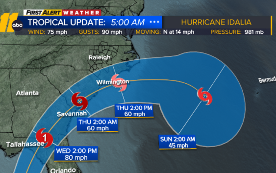
RALEIGH, N.C. (WTVD) — Tuesday morning, Idalia strengthened into a category 1 hurricane. Idalia is forecast to rapidly intensity over the eastern Gulf of Mexico.
It’s forecast to be a category 3 (major hurricane) just before landfall near Cedar Key, Florida Wednesday morning.
Idalia will lift northeast across Savannah Georgia later Wednesday to a position along the Carolina coast Thursday.
This path will spare the Triangle of the worst of this storm with the northwest flank producing rains of 1-3 inches along with gusty winds.
This rainfall can renew flooding conditions following the last few days. The winds may be just strong enough to trigger scattered power outages.
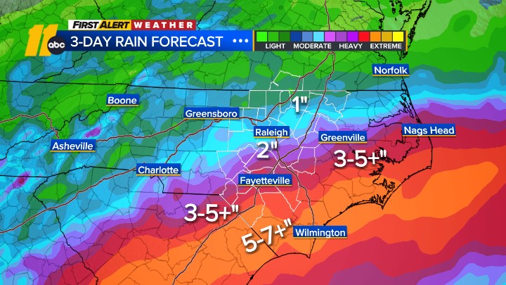
Expected impacts for Central NC Wed night through Thursday afternoon
- Heavy rain (2-6″)
- Gusty winds of 35-55+mph possible
- Power outages
- There is an isolated tornado risk south in Sampson and Cumberland Counties
Hurricane Idalia makes a small westward shift which will bring the rain shield into more portions of Central NC late Wednesday into Thursday afternoon
It will be much worse toward the coast where sustained tropical storm force winds and gusts, to near hurricane force, will result in extensive wind damage.
Rainfall of 4-8 inches will trigger flooding and result in road closures.
Beach conditions will deteriorate as rip currents and high surf develop as Hurricane Franklin moves by well to the east.
Rough surf and dangerous rip currents will continue through Thursday.
Idalia’s effects on the Triangle are expected to wind down Thursday night, although conditions will not improve along the coast until Friday.
Copyright © 2023 WTVD-TV. All Rights Reserved.
Related Topics