- Carolina Beach is warning of potential King Tide flooding
- NCDEQ launches Hurricane Helene recovery grants program
- Why no hurricanes made landfall in the US in 2025
- Florence to begin interviewing police chief finalists in January
- A West Texas county wants to better prepare for floods. Paying for it will be tricky.
Brad Panovich: How Hurricane Idalia will impact the Carolinas
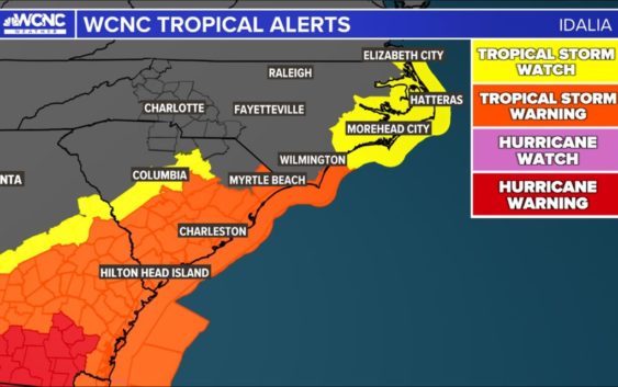
Idalia made landfall in Florida as a Category 3 hurricane with sustained winds near 125 mph. It could produce heavy rain, high winds and flooding in the Carolinas.
CHARLOTTE, N.C. —
Idalia update
Idalia (ee-DAL-ya) made landfall along Florida’s Big Bend area around 7:45 a.m. Wednesday as a strong Category 3 hurricane. Idalia had estimated wind speeds of around 125 mph, according to the National Hurricane Center. Idalia’s landfall happened at Keaton Beach in Taylor County, which is near the city of Perry.
Water levels along the Big Bend of Florida are rising rapidly with a reported level of 5.9 feet in Cedar Key. Idalia could create devastating or catastrophic storm surges in coastal areas up to 10 feet. It’s a fast moving hurricane, traveling at about 20 mph.
“The faster the storms move, the slower it takes for the winds to calm down,” WCNC Charlotte chief meteorologist Brad Panovich said in his latest weather vlog. “What happens is, as storms go over land, they weaken. But if it’s flying, there’s not enough time for that wind to calm down. So you can bring really strong, hurricane-force winds well inland.”
Idalia is the second major hurricane in the Atlantic Basin. Florida’s Big Bend is the coastal area between the panhandle and peninsula of the state.
Idalia officially became a hurricane at 5 a.m. Tuesday and quickly strengthened to Category 2 status by 5 p.m. As the storm moved north over warm waters in the Gulf of Mexico, it rapidly intensified to Category 4 status at one time Wednesday before coming ashore as a Category 3.
South Carolina and North Carolina coastal impacts
Storm surge is one of the main impacts for communities along coastline of South Carolina and North Carolina . The low country of South Carolina can expect a storm surge or at least 3 to 5 inches, but high tide could bring this total higher because Hurricane Franklin — which did not hit land — is producing life-threatening surf and rip currents along the southeast coast.
“The biggest threat though in the Carolinas is going to be the southern Pamlico Sound because we’ve got all this rain from this week, and from the rain from the storm trying to push out of the rivers, but water is being pushed in by the surge in the wind, so that water can’t go anywhere,” Panovich explained in his vlog. “So it spills over the banks, gets pushed into all those bays and canals and swamps and rivers, and it just overflows There’s just nowhere for the water to go.”
For the latest weather alerts, download the WCNC Charlotte mobile app and enable push notifications.
Panovich warned that some of the inner coastal areas could see some significant water because of the astronomical high tide, so people will need to keep their guard up. As a reminder, forecasts can change quickly, so please keep checking back for updates from the WCNC Charlotte Weather Team as the forecast pivots.
For the Charlotte area, rain will start to progress in the afternoon hours of Wednesday. The flash flooding will be worst around 10 p.m. Wednesday. The back edge of Idalia will start to move in overnight, most likely around 1 a.m. Thursday.
“This is going to be a 12-hour window of maybe 3 or 4 [p.m.] to 3 or 4 [a.m.] tomorrow for Charlotte, and then it’s out of here,” Panovich outlined in his vlog.
This hurricane is officially the 130th documented category 4 hurricane and currently the strongest of the 2023 Atlantic Hurricane Season.
Contact Brad Panovich at bpanovich@wcnc.com or follow him on Facebook, Twitter and Instagram.
Contact KJ Jacobs at kjacobs3@wcnc.com and follow him on Facebook, Twitter and Instagram.
Contact Chris Mulcahy at cmulcahy@wcnc.com and follow him on Facebook, Twitter, Instagram and TikTok.
Contact Brittany Van Voorhees at bvanvoorhe@wcnc.com and follow her on Facebook, Twitter and Instagram.
Contact Larry Sprinkle at lsprinkle@wcnc.com and follow him on Facebook, Twitter and Instagram.
WCNC Charlotte’s Weather IQ YouTube channel gives detailed explainers from the WCNC Charlotte meteorologists to help you learn and understand weather, climate and science. Watch previous stories where you can raise your Weather IQ in the YouTube playlist below and subscribe to get updated when new videos are uploaded.