- Why no hurricanes made landfall in the US in 2025
- Florence to begin interviewing police chief finalists in January
- A West Texas county wants to better prepare for floods. Paying for it will be tricky.
- They couldn’t save their daughters’ lives in the July 4 floods. Now they’re dealing with the grief and the guilt.
- Austin could see heavy rains, possible flooding over the next few days
Latest Tropical Storm Ophelia: NC state of emergency; flood watches, warnings in effect
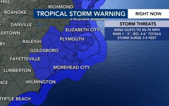
Tropical Storm Ophelia on Friday and Saturday will bring rain and storms to North Carolina. The storm is expected to make landfall Saturday morning along the N.C. coast.
Friday afternoon, Ophelia was 200 miles south of Cape Hatteras with maximum winds at 50 mph. Ophelia will bring tropical storm conditions and heavy rain to our coast. Locally, we will see rain, gusty winds and some storms.
Gov. Roy Cooper has declared a state of emergency for North Carolina. A WRAL Weather Alert Day starts Friday at 7 p.m. and lasts until 3 p.m. Saturday, when the biggest impacts will be felt.
Tropical Storm Ophelia: What to know
Track rain with the DualDoppler5000 | 9 things to do on a rainy day in Raleigh | Live look at conditions across NC | Download the WRAL News app to get alerts | Photos show timing, impact
Live updates:
3:30 p.m.: Power outages will be likely Friday night and Saturday. Spokesperson Jeff Brooks said Duke Energy is ready to send extra crews to the coast if needed.
“Tomorrow is going to be a busy day,” Brooks said on Friday. “Tonight could be busy, and our crews will be on standby to restore outages as they occur.”
Brooks said there is a chance for outages in the Triangle even though conditions will be worse in eastern North Carolina.
“We are looking at 25 to 35 mph winds gusts … 40 mph is right on the line for outage effects,” he said.
Brooks suggests people prepare a storm kit in case they lose power. You can also download the WRAL News app to get alerts.
“When we have a lot of outages during storms we can’t always prioritize you, can’t always guarantee it will be back on in an hour,” he said. “Make sure you have a plan in place to keep your family comfortable.”
3 p.m.: Gov. Roy Cooper declared North Carolina under a State of Emergency due to Tropical Storm Ophelia. A state of emergency betters enables North Carolina Emergency Management to respond to flooding and other severe weather.
“This is a proactive preparedness measure to ensure we have the tools and resources available to support all North Carolinians,” said Will Ray, Emergency Management director.
Flooding and power outages will be most likely east of the Triangle and at the coast.
2:50 p.m.: Maximum wind gusts recorded in NC include 50 mph at Rodanthe and 52 mph at Cape Lookout. Some coastal towns have already seen 2 inches of rain.
Tropical Storm Ophelia: Timing, impact
A tropical storm warning is in effect for counties directly east of the Triangle, including Edgecombe, Halifax, Nash, Sampson, Wilson and Wayne counties.
A flood watch is in effect for Edgecombe, Franklin, Halifax, Johnston, Nash, Sampson, Vance, Warren, Wayne and Wilson counties until 9 p.m. on Saturday.
A potential tropical cyclone strengthened into Tropical Storm Ophelia on Friday with peak winds near 60 mph as it approaches our coast. Ophelia could make landfall Saturday morning near Morehead City.
Rain on Friday afternoon will become more widespread by late afternoon and evening.
“The bulk of the rain arrives after 2 p.m. Friday,” said WRAL meteorologist Kat Campbell. “The heaviest rain and strongest winds will come overnight into early Saturday (8 p.m. to 11 a.m.).”
The Triangle could see wind gusts up to 35 to 40 mph, and eastern counties could see gusts up to 40 to 45 mph.

Counties east of the Triangle are under a Level 1 out of 5 risk for severe storms, and a Level 2 threat is in place at the coast. Flooding and power outages will be possible Friday and Saturday for those eastern counties.
“It will be worse the closer you get to the coast,” WRAL meteorologist Anthony Baglione said. “It still looks like our main concerns [in the Triangle] will just be windy and rainy conditions, although an isolated strong storm can’t be ruled out. Winds will gust 30 to 40 mph [locally] with 50 to 75 mph gusts along the coast.”

Up to 4 inches of rain will be possible Friday and Saturday in our eastern counties and along the coast. In the Triangle, we’re expected to get 1 to 2 inches of rain.

The National Hurricane Center said tropical storm conditions are expected along the coast, where tropical storm warnings and storm surge watches are in effect.
“We could see around 2 to 5 feet of storm surge for areas north of Surf City with up to 3 feet south of Surf City,” Baglione said.
“There is a danger of life-threatening storm surge inundation over portions of eastern North Carolina,” the NHC said Friday morning.


If you’re planning on heading to the beach this weekend, apart from the rainy weather, there’s a high rip current risk.
Potential Tropical Cyclone 16 will bring dangerous rip currents to the NC coast, and a heavy surf advisory is in effect. It’s important to stay safe if you’re heading to the beach this weekend. Avoid going in the water if you see yellow or red flags.

The state is urging North Carolinians to be prepared and stay safe. Make sure you have an emergency kit with the following necessities:
- Food
- Make sure you have food that’s ready to eat and doesn’t need to be refrigerated, in case there’s an outage.
- It might be a good idea to pick up a cooler and some ice. That way you can salvage some groceries if there’s an outage.
- Water
- Phone charger
- A portable charger is best since traditional chargers won’t work during an outage.
- Prescription medications
- First aid kit
- Flashlight
- Batteries

After Ophelia: Looking ahead
Heavy rain will continue overnight into Saturday morning. Showers will become more scattered by Saturday afternoon after the WRAL Weather Alert Day ends at 3 p.m.
“Rain and storm chances continue into just after lunchtime tomorrow with all of this likely gone by the 6 p.m. Saturday night,” Baglione said. “Sunday looks beautiful with sunshine and warmer highs in the 70s.”
Sunday will be the best day to get outside this weekend. The rain should clear out by Sunday morning, and it’s supposed to warm up a bit.