- Why no hurricanes made landfall in the US in 2025
- Florence to begin interviewing police chief finalists in January
- A West Texas county wants to better prepare for floods. Paying for it will be tricky.
- They couldn’t save their daughters’ lives in the July 4 floods. Now they’re dealing with the grief and the guilt.
- Austin could see heavy rains, possible flooding over the next few days
Severe weather possible through Monday
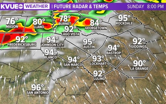
We’re tracking a second line of storms that won’t necessarily roll in until 12 p.m. on Monday but may roll in earlier or later depending on the speed of the frontal system.
The SPC has placed southern portions of the KVUE area under a “marginal” – one out of five – risk for severe weather. But we don’t expect much severe weather in our area, largely due to the front being to our south and a northerly flow across the region limiting daytime heating.
Models have been at odds over rainfall totals from this system and where the heaviest rain will be. This is common for systems like this, but we’re generally looking at half an inch to an inch-and-a-half. Some of the areas with the heaviest rain could get totals up to 3 inches or more, creating a minor flash flooding concern.
Stick with KVUE for the latest on this developing forecast.
In the meantime, your extended forecast is below.