- Families of campers, counselors who died in Texas Hill County floods sue Camp Mystic
- Small plane bound for Jamaica with hurricane relief supplies crashes in Florida neighborhood
- Ask the Meteorologist: Did a tornado hit Johnston County Saturday night?
- Demolition begins on flood-damaged homes in Stoney Creek as neighbors await relief
- NC Office of State Fire Marshal aiding in Hurricane Melissa relief efforts
Live updates: Tornado watch possible for coast on WRAL Weather Alert Day, flood watch in effect
Sunday is a WRAL Weather Alert Day, and we’re already seeing heavy rainfall across the Triangle.
A flood watch has been issued for our entire viewing area until Monday at noon.
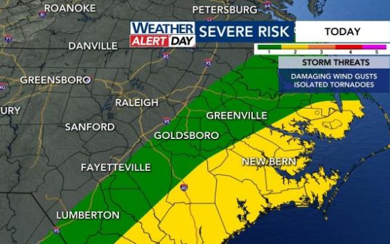
The severe threat will be greatest east of Interstate 95. Flooding will be possible, as well as damaging winds and possibly an isolated tornado. It will be breezy with wind gusts up to 40 mph.
WRAL Meteorologist Aimee Wilmoth said the rain will be heavy through Sunday evening. She said the best chance for severe storms will be later in the evening.
Into the afternoon and evening, there is a slight chance for thunderstorms in the Triangle. The Triangle is under a Level 1 risk for severe storms. The risk is greater to the south and east of Raleigh.
Live updates
Noon: Heavy rainfall continues.
11 a.m.: Heavy rainfall in the Triangle.
10 a.m.: Rain continues.
9 a.m.: Widespread rain.
3:45 a.m.: Flood watch issued for entire viewing area until Monday at 6 a.m.
