- North Carolina’s leaders give insight on the effects of Hurricane Melissa
- ‘We want some answers;’ Whiteville residents demand city response to prevent flooding
- Halifax County couple OK after riding out Hurricane Melissa in Jamaica
- Hurricane Melissa leaves 25 dead in Haiti, causes widespread damage in Jamaica and Cuba
- Category 5 Hurricane Melissa brings flooding and catastrophic winds to Jamaica
What San Antonians need to know this year about hurricane season
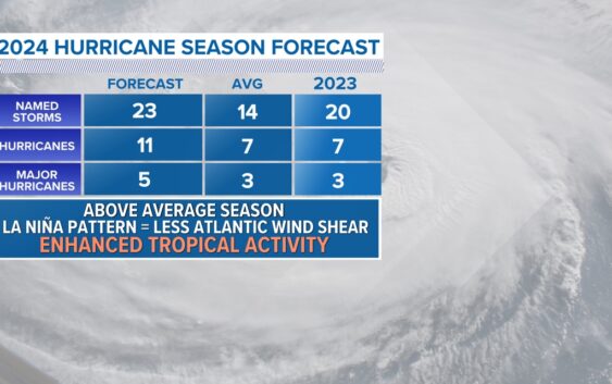
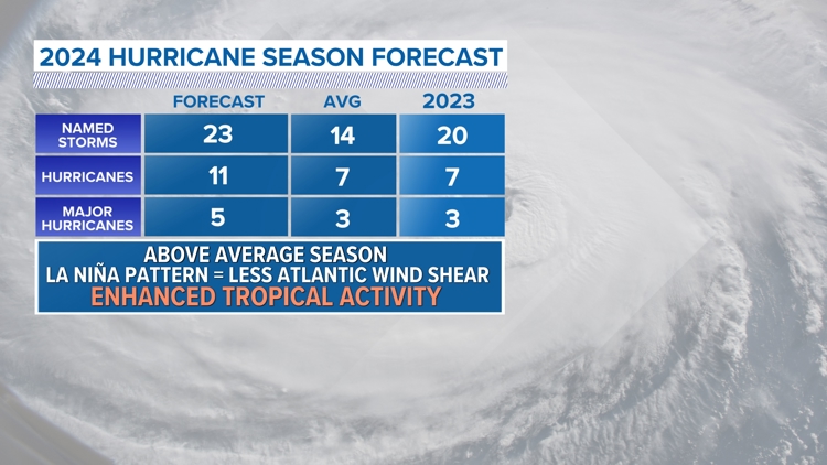
SAN ANTONIO — Hurricane season will officially begin on June 1 and the Atlantic is expecting enhanced tropical activity due to change in the long-range pattern in the Pacific and Atlantic Ocean.
Sea surface temperatures off the coast of South America will trend cooler in the coming months which will lead to a La Nina Pattern in the Pacific.
This teleconnection impacts weather and climate across the globe including the Atlantic hurricane season. Moreover, this typically creates less wind shear in the Atlantic Ocean helping to fuel thunderstorms and tropical cyclones.
Due to this transition on ocean temperatures, the latest forecast calls for an active season with upwards to twenty three named storms. Eleven of those expected to become hurricanes and five storms over Category 3 status, which is considered major hurricane status.
Just because we call for an active season doesn’t mean each storm will hit land. In fact, most storms that form stay out at sea. However, it only takes one storm to make an active year!
The Atlantic hurricane season runs through November 30th.