- They couldn’t save their daughters’ lives in the July 4 floods. Now they’re dealing with the grief and the guilt.
- Austin could see heavy rains, possible flooding over the next few days
- Families of campers, counselors who died in Texas Hill County floods sue Camp Mystic
- Small plane bound for Jamaica with hurricane relief supplies crashes in Florida neighborhood
- Ask the Meteorologist: Did a tornado hit Johnston County Saturday night?
Photos and videos show high water along Texas coast from Tropical Storm Alberto
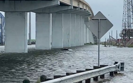
These are submissions from our KHOU 11 News crews and viewers.
GALVESTON, Texas — Tropical Storm Alberto formed Wednesday well to the south of Texas, but the effects of the storm were being felt up and down the state’s coastline.
While showers and storms have been persistent across the Houston area, the storm has pushed the tide inland, pushing water onto streets and into yards. It’s also bringing rough seas to parts of the coast.
If you have photos or videos of high water, share them through the Near Me feature of our app.
We’ll start with this video in Sea Isle on the west end of Galveston. George and Alice Jensen have been shooting plenty of video that we’ve been sharing on social media, including this one showing water that’s at least shin deep.
Our partners at Saltwater-Recon captured video of a waterspout moving offshore on Jamaica Beach.
Heading down to Surfside in Brazoria County, reporter Jason Miles captured this video of an abandoned car almost completely underwater.
Meanwhile, down in Corpus Christi, the wind has really picked up. That’s where KHOU 11’s Matt Dougherty is right now.
The water was also rising in Clear Lake Shores, where viewer Amanda Fenwick shot this video.
High water in Clear Lake Shores, Wednesday 6/19
On Bolivar, the high water was causing problems on the road.
In Bay City, water was flowing into yards.